
 |
|
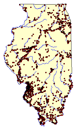
Map of Illinois showing locations of Mississippian sites. |
At present, archaeologists have recorded 2,379 Mississippian sites in Illinois. When divided by the length of the period-550 years-there are 4.3 sites per year. This is slightly less than the ratio of sites per year calculated for the Woodland Period. Why? Mississippian sites tend to be larger, suggesting greater concentrations of people in a smaller number of communities. Study the map. Do you notice how many of the Mississippian communities are concentrated along the major rivers of Illinois?
Mississippian settlements are found throughout Illinois, mainly along large rivers and streams such as the Wabash, Big Muddy, Kaskaskia, Spoon, Ohio, Illinois, and Mississippi rivers. The pattern of settlement is repeated in all of these areas. Let's look at an example from southern Illinois.
The Kincaid site and the remains of many other Mississippian settlements have been found in the Black Bottom along the Ohio River in Pope and Massac counties. Farmsteads, hamlets, villages, and larger communities such as Kincaid, dot the Ohio River flood plain, which is a series of ridges and swales. Perhaps as many as 1,500 people lived here during the Mississippian period.
The center of Mississippian life in the Black Bottom was Kincaid. Lying at the edge of Avery Lake, the ancient city of Kincaid covered 175 acres, all of which was enclosed by a log wall. In the city center were several flat-topped earthen mounds, on top of which were buildings, perhaps the residences of important people.
Much like our lives today, Mississippian farmers in the Kincaid vicinity provided food for larger communities in exchange for other items such as stone hoes and other tools.
This pattern of central cities surrounded by villages, hamlets, and farmsteads, is repeated in many parts of Illinois. Some Mississippian centers include Cahokia, located in the American Bottom near East St. Louis; the Larson site, located at the confluence of the Spoon and Illinois rivers in Fulton County; and the Otter Pond site, located along the Embarrass River in Lawrence County.
|
|
Copyright © 2000 Illinois State Museum