
 |
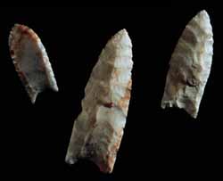
Paleoindian spear points, Fulton County, Illinois. | |
|
Note the groove or flute extending from the base of the point. This characteristic of Paleoindian points makes them distinctive when compared with points made at other times. |
||
The first people in North America arrived at least 14,000 years ago. Archaeologists call this period of North American history Paleoindian, meaning ancient Indian. Paleoindian people left behind distinctive spear points, such as the ones seen here, and other kinds of stone tools at Illinois camp sites. Archaeologists have yet to find charcoal from which they could get an absolute date for these camp sites, but spear points similar to those illustrated here have been found in other parts of North America in 10,000 to 12,000-year-old deposits. Who were the Paleoindians, and from where did they come?
 |
|
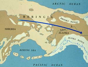
Map of Asia and North America showing Beringia and the possible routes of Paleoindian people. |
The first people to live in North America came from Asia at least 14,000 years ago. They arrived near the end of the Pleistocene epoch, which is also known as the Ice Age. Archaeologists believe the first Americans crossed into North America when it was connected to Asia by land. Why aren't these continents connected by land today?
Geologists estimate that ocean levels were at least 280 feet lower during the late Ice Age. When sea level fell, sections of ocean floor became dry land. For example, large parts of the continental shelf were exposed along the coasts of North America and land linked Asia and North America. Where was the water?
The earth's climate was colder during the Ice Age than it is today. During the Ice Age snow made up much of the earth's precipitation. Thick layers of snow slowly accumulated at higher latitudes and higher elevations. As snow accumulated, the bottom layers were compressed and transformed into ice and eventually glaciers, slow-moving masses of ice. In North America, glaciers once stretched from the Arctic to southern Illinois. As more and more of the earth's water was transformed into snow and ice, ocean levels fell, exposing large sections of ocean bottom.
Asian people walked across this Asia/America "land bridge", perhaps while hunting animals like the woolly mammoth (Mammuthus sp.). Archaeologists call the land bridge Beringia. About 12,000 years ago, rising sea water submerged Beringia, which today lies beneath the Bering Sea. Why did the sea level change? When the earth's climate became warmer, glacial ice melted, sea level rose and submerged land along the edges of continents.
|
|
Copyright © 2000 Illinois State Museum