
The
survey crew
When
a deputy surveyor contracted with the government to survey land, he hired
a crew consisting of one or more axemen, flagmen, chainmen, and sometimes
others.
Tools
and Methods
The surveyors
were responsible for the accuracy of the equipment, which included a compass
(and later a solar compass, patented in 1836, which told the time and true
meridian) and the chains used to measure the distance between township
and section corners. The surveyors measured distances in chains and links.
One link is 7.92 inches long.In order to mark the regular grid system of townships and sections on the ground, the surveyors usually placed a post at each township and section corner, as well as at quarter-section corners halfway between the section corners.
There are 100 links to each chain.
A chain is 66 feet long.
There are 80 chains to the mile.
A mile is 5,280 feet.
Bearing
Trees
To help locate the post, or in the event that the post was destroyed, the surveyors blazed 'witness' trees near the post in forested areas or built an earth mound with trenches around the post in prairie. The surveyors recorded all or some of the blazed trees in their notebooks, and these are known as bearing trees. It is these bearing trees that are so valuable to modern-day ecologists when they are reconstructing the vegetation at the time of the survey.
Bearing trees were not a random sample of the forest trees, however. Surveyors chose them based on size, closeness to the corner post, and probability of long life because the purpose of a bearing tree was to help relocate the corner in the future. The trees recorded were in fact there; however, in any one area the choice of trees was limited.
The surveyors recorded the bearing trees by their common name (e.g., 'black oak'), their diameter in inches, their distance from the corner post in links, and the compass bearing from the post. They also described the vegetation after each survey mile or sometimes half-mile.
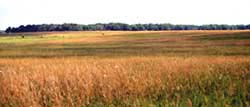
Surveying the prairie - what if there were no trees to record?
When surveyors entered stretches of treeless prairie, they erected mounds of earth in which a post was placed to mark section and quarter section corners. The mounds were cut from the prairie sod, which was stacked layer upon layer in a pyramid-shaped arrangement to a height of 3 feet. Sometimes, when a post was not set into the mound, large stones or charcoal were buried within it. Once again, surveyors provided a general description of the land after surveying each section line. In the prairies, descriptions were often brief, for example, "Land prairie, gently rolling, 2nd rate."
Link to classroom Forest Activity on Land Surveying (pdf format).
|
|
Copyright © 2000 Illinois State Museum