
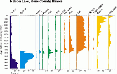
The pollen diagram is from Nelson Lake, Kane County Illinois. It is one of the longest, most complete late-glacial and Holocene (the last 11,500 years) records for Illinois. Today it is the location of Nelson Lake Marsh Nature Preserve, just 35 miles west of downtown Chicago.
How
the diagram tells the story
The y
or
vertical axis of this diagram (the labels going down the left side), show
the age of the pollen samples, from 17,000 years old at the bottom. Today's
pollen samples are at the top of the diagram (near the zero).
The x or horizontal axis of this diagram has percentage (numbers going from left to right). Each plant species has a set of percentages. This axis measures what percentage of all the pollen found in one core section belonged to each species.
The names of the plants from which pollen was found are located across the top of the diagram.
Put these all together and we can interpret the data, marked in purple ink: (about 17,000 years ago)
- Sedge pollen was found to make up 35 per cent of all samples 17,000 years ago.
- If you continue across with each species of plant at 17,000 years ago (bottom of the diagram) you will see that spruce trees (in blue) accounted for 25 per cent of all pollen counted.
- Add up sedge and spruce and you have 60 per cent of all the pollen.
- All the rest of the plant pollen found adds up to the other 40 per cent to make 100 per cent. There was grass and ragweed in the herbaceous layer, and a few of all the other tree types (in green) listed grew in that area, too.
Spruce
forest
This
diagram also shows that about 14,000 years ago,
- the spruce forest became more closed (more trees growing close together - up to 50 per cent of all pollen counted.
- At the same time, sedge cover decreased (to less than 25 per cent), and ash appeared in the forest.
The
forest is in transition
Spruce
began to decline. By about 12,000 years ago tree species that would be
dominant in a different type of forest were starting to spread. Balsam
fir, aspen, and birch (green ink in diagram), appeared as the climate became
warmer and wetter.
Deciduous
forest
Ash peaked
(at 25 per cent in the diagram) between 12,000 and 11,000 years ago, when
elm and oak (orange ink in diagram) were increasing. By 11,000 years ago,
the spruce was gone, and deciduous
forest with elm, ash, alder, ironwood, and oak took over. Ash and elm,
which today grow on poorly drained soils, indicate high rainfall during
this period.
Prairie
openings in the forest
After
11,000 years ago, oak became more abundant (up to 40 per cent of total),
and hickory appeared. Elm and ash declined, but elm remained important
in the forest until about 6500 years ago. Increasing grass and ragweed
(yellow ink in diagram) after 11,000 years ago indicate the local development
of prairie openings, but forest prevailed over much of the landscape until
about 6500 years ago.
Prairie
developed
After this time, the tall-grass prairie with scattered groves of oak developed. The development of prairie indicates a trend towards drier climate during the Holocene (our current interglacial). Nelson Lake does not show it so well, but other sites in the region indicate the driest interval was from about 6500-3500 years ago.
The
rise of today's landscape
Perhaps
you noticed that the diagram was organized to reflect that the species
that grew at Nelson Lake during the oldest time period (on the left of
the diagram) were slowly replaced by species farther and farther to the
right (green to orange to yellow inks). Species that were barely able to
survive in the cold glacial climate now grow abundantly. The evergreen
and other cold climate trees that grew well during the Ice Age disappeared
as the climate warmed.
After 3500 years ago, the essentially modern mosaic of prairie and groves developed. The big increase in grass at the top of Nelson Lake is from aquatic grasses, perhaps wild rice, which became common as the lake filled with sediment and a large wetland developed around Nelson Lake.
Arrival
of European Settlers
The uppermost
portion of the pollen diagram shows an increase in ragweed about 200 years
ago. This coincides with the time of European settlement. As the settlers
plowed the prairie sod and cultivated crops, ragweed populations exploded
and native grasses and other prairie plants declined. During this time,
many forests were removed as well, for fuel, building materials and agriculture.
For more practice in reading this diagram, see the Pollen Graph Activity.
|
|
Copyright © 2000 Illinois State Museum