
Information from maps created by early land surveyors indicates that prior to European settlement approximately 38% (13.8 million acres) of Illinois was forested and 61% was prairie. Most forests were comprised of oak and hickory, and forests containing these trees were present throughout the state. The most common oaks were white, red, bur, and black oaks. Common hickories included shagbark, pignut, and bitternut hickories.
The
north
The northern counties were mostly prairie, with major forests occurring in the extreme northwestern counties along the Mississippi River and in Lake County in the northeastern section of the region. The forests in the region ranged from upland forest to floodplain forests along rivers, and wet forests and shrub swamps associated with glacial kettles.
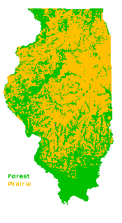
Forest in Illinois circa 1820. Anderson, 1980 Notice the green (forests) extend along rivers and fill the southern and northwest tips of the state. |
The
prairie region
The Grand Prairie Region, in the central portion of the state, was dominated by tallgrass prairie. Less than 20% of the region was forested. Groves, savannas, sand forests, and forests associated with prairie streams and rivers comprised the timber for the region. The area between the Illinois and Mississippi Rivers had both prairie and forest, with major forests being distributed along the rivers. Floodplain forests and upland forests associated with river bluffs occurred along the major rivers and streams that dissected the central glacial plains and the western parts of the state. |
The
south
The percentage
of forest cover was greater, primarily along streams and rivers, to the
south of the Grand Prairie Region. The greatest continuous forest cover
was in the southern portion of the state, with the southernmost counties
in the Shawnee Hills almost exclusively forested. These southern counties
also had the greatest variety of trees. Forests ranged from upland forests,
barrens and flatwoods to cypress swamps and the bottomland forests along
the lower Wabash River. No prairies were recorded for the counties along
the southern border of the state (including Johnson and Union counties).
Ecotones:
areas where forest mixes with prairie
It is
not always clear where forest stops and prairie begins. There are transitional
areas where groves of trees appear in and around prairies. French explorers
called them Iles de bois, islands of woods.
In general they give the name l'ile de bois (isle of woods) to a group of trees that one finds in the great prairies and which are protected from fires by streams or water or other irregularities of the terrain.European settlers on the prairie needed a source of material for fuel, building houses, and tools, utensils, and furniture. The Europeans came from forested countries and had used mostly wood. The transitional areas furnished wood, yet were near the more open grassland.
- Joseph Nicollet, 1838
|
|
Copyright © 2000 Illinois State Museum