
 |
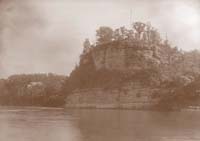
Starved Rock, La Salle County, Illinois. Photograph by Frank Thone, 1922. Illinois State museum (ISM 1953-92) |
The nature and pattern of remains on the summit of Starved Rock are consistent with the identification of Starved Rock as le Rocher of the French and the location of the first Fort St. Louis constructed in Illinois--that built for La Salle by his lieutenant Henry de Tonti in the winter of 1682-83. (Robert L. Hall, 1991)![]()
Starved Rock, with its 38 m high sandstone cliff, is the most prominent natural landmark on the upper Illinois River. The rock, called "le Rocher" by the French, was selected by La Salle as the site of Fort St. Louis because of its readily defensible location. Henry de Tonty built the fort to La Salle's specifications, finishing it in the spring of 1683. The fort was protected by a wooden palisade and contained a chapel, a warehouse or magazine, and several other buildings. It was abandoned by the French in 1691, when the Kaskaskia vacated their village across the river, but was reoccupied by the Peoria in the early 1700s. Starved Rock received its name for an event that allegedly took place there about 1770. According to Native American tradition, some Peoria Indians who came under attack by a war party of Potawatomi Indians suffered starvation when trapped on the rock without food or water.
![]()
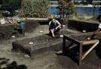
Archaeological excavations at the Starved Rock site, 1949. Archaeologists passed the excavated sediment through metal screens mounted on wood frames, as seen at the right, to systematize the recovery of artifacts. Illinois State Museum (ISM 195-97)
Excavations were undertaken on Starved Rock in 1947 by the joint Illinois State Museum and University of Chicago crew working at the Zimmerman site. The Museum-University team continued its work on the rock in 1948-1949, and in 1949-1950 it was joined by a crew from the Illinois Department of Public Works and Buildings. Some additional work was conducted at the site in the 1970s and 1980s.
![]()
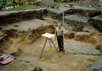
Archaeologist Richard Hagen standing in the excavated cellar (Feature 13) at Starved Rock, 1949. The cellar probably underlay a powder magazine or warehouse built in 1683 as part of La Salle's Fort St. Louis. Strings mark a grid of 5-foot squares used to orient the 1949 excavations. Illinois State Museum (ISM 1957-97)
The Starved Rock excavations uncovered the remains of a long series of prehistoric Native American occupations dating from the late Paleo-Indian period of more than 10,000 years ago to more recent cultural periods. Evidence of La Salle's Fort St. Louis includes numerous artifacts of European manufacture, the most significant of which is an embossed lead bale seal that dates to the reign of Louis XIV (1643-1715). The bale seal was found in a square cellar that Tonty evidently constructed beneath a powder magazine or warehouse.
The structure burned after the fort was abandoned, partially filling the cellar with charcoal, ash, and building hardware. Eroded sediment then washed into the cellar depression, and several Native American graves were then buried in this fill. One of these, the grave of an infant who died before the age of three, was buried with several strings of glass beads and a leather necklace strung with ten brass Jesuit rings. The Jesuit rings date to a very specific time and indicate that these and other historic graves on Starved Rock are affiliated with the Peoria tribe's 1711-1722 occupation of the site.![]()
|
|
Copyright © 2000 Illinois State Museum