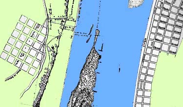
The Formation of Bloody Island. Illinoistown is on the left, St. Louis on the right.
Image Credits
The course of the Mississippi
The Formation of Bloody Island.
Rivers are dynamic. Over time they change
direction, become filled with debris,
flood, and silt up. People rely on rivers
to be accessible for transportation and
travel. In the 19th century the Mississippi
River was important to the growth of St. Louis and
Illinoistown.
People in both places came to rely on the river because much of
their business depended on their ability to receive and ship goods
by water.
Beginning around 1800 the river began to change course, moving
closer to the Illinois side and further from St. Louis, threatening
that the city would become land-locked. A sandbar on the Illinois
side appeared just above Illinoistown. The original riverbank
began to erode with the increased flow of water against it. Not
long after the appearance of this sandbar one grew on the Missouri
side filling in the gap between the shore and the sandbar. During
the next twenty years the sandbars continued to grow. The southwestern
sandbar became known as Duncan's Island while the much larger
sandbar on the Illinois side was called Bloody Island. The name
came from the sandbar's popularity as a dueling field due to its
neutral location, technically outside of both states.