Read More About It - Glacial Landforms
Rock, gravel, sand, and silt left behind by melting glaciers formed mounds, ridges, and thick windblown deposits.
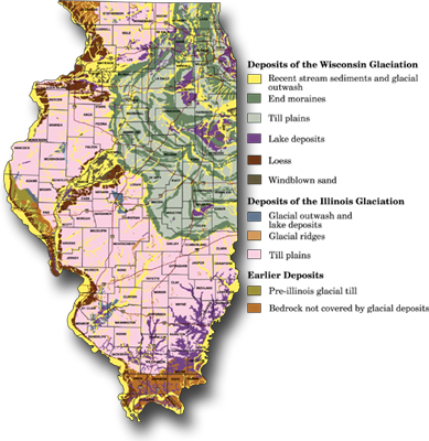
End Moraines — During periods when the rate of ice advance nearly equaled that of melting, huge mounds of sand and gravel piled up in curved ridges along the glacier's edge. The end moraines from the Wisconsin glaciation are can be seen in northeastern Illinois.
Kames — Smaller mounds of sand and gravel formed where sediment filled cracks in the ice.
Kettles — Depressions formed when ice broke into chunks that became buried in sediment. When the ice block melted, it left a depression, which sometimes filled with water to form kettle lakes. Kettle lakes are common in northern and central Illinois.
Eskers — These are long, winding ridges of sand and gravel formed in waterways under the glaciers.
Outwash Plains — At the glacial front, water flowing from underneath the ice formed level plains of fine sediment.
Loess Deposits — During the cold seasons, the flow of glacial meltwater slowed. Fine silt that had been deposited on the outwash plain and along river channels leading from the glacier was exposed and dried out. Winds blew the dust to surrounding areas where it slowly grew into thick silt deposits called loess. Vertical faces of loess, sometimes over 30 meters (about 100 ft.) high, can be seen along the Mississippi and Illinois River valleys.