Late Prehistoric sites with mounds and ca. 1800 locations of the Mississippi River and wetlands.
|
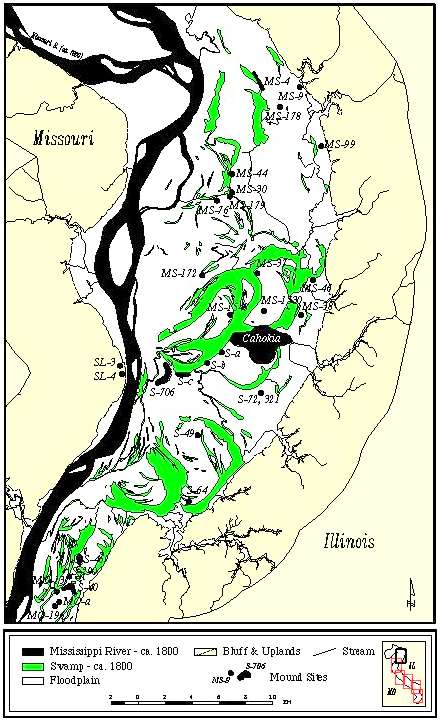
Late Prehistoric sites with mounds and ca. 1800 locations of the Mississippi River and wetlands. |
These maps and other geological data clearly show that the river position has been relatively stable in the American Bottom for the last several hundred years. Thus, the record of Mississippian archaeological sites in the American Bottom has not been biased by destruction of sites by shifting channel locations. Moreover, these historical data demonstrate that prior to the late 19th to early 20th century wetlands and swamps were major physiographic features, spread out across much of the American Bottom. For the entire central Mississippi River valley (from Grafton to Thebes Gap) the PLS data indicate that rivers, wetlands, swamps, lakes and sloughs covered on the order of about 35% of the valley. Excluding the Mississippi River and islands, about 19% of the valley floor was water covered. In some places over 50% of the floodplain area was underwater for a good part of most years. For the area surrounding Cahokia, over 15% of the valley floor was permanently underwater. These are highly conservative estimates of water covered ground because, for example, early surveyors tended to slog through most shallow water areas and typically mapped only the deepest water bodies. |
Low areas such as old channel scars, sloughs, and swales were poorly drained, often containing deep, clay-rich "mucks." Many were filled by shallow lakes, slow moving streams, or seasonal ponds. The more elevated areas, once point or channel bars and natural levees, remain better drained. They typically contain more silt and sand. Alluvial fans created where streams from the uplands spilled onto the valley and colluvial fans that formed aprons at the bluff base, also contained coarser deposits and were better drained.