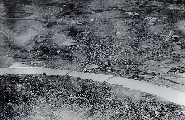
Aerial photo looking east over St. Louis, Missouri towards East St. Louis and Cahokia, Illinois, 1922 Goddard photo.
Although often wet and densly vegetated, Euroamerican settlers recognized that the bottomland soils were extraordinarily fertile, excellent for farming. Thus, starting as early as the mid-19th century, Euroamerican settlers began digging ditches, tiling fields, and building levees to drain what had previously been an extensive network of wetlands, swamps, and sloughs. What is now a patchwork of modern economic development was made possible by two attempts (successful at least in the short term) to mold the natural environments of the American Bottom. Around the turn-of-the-century, to facilitate transportation, economic development, and protect residences, urban infrastructure, and agricultural facilities from flooding, considerable efforts were made by both the public and private sectors to control the Mississippi River through a system of levees, boat locks, dams, dikes, and drainage ditches. Thus, it is not surprising that the open, flat, and well-drained agricultural American Bottom we see today is radically different from the environment of 1000 years ago when Native Americans, called Mississippians by archaeologists, lived here.
Aerial photo looking east over St. Louis, Missouri towards East St. Louis and Cahokia, Illinois, 1922 Goddard photo.
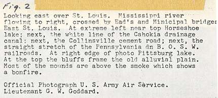
Original caption for above Goddard photo, 1922.
|
As indicated by the above quotes, only 150 - 175 years ago this expansive floodplain appeared far different from the (seemingly) topographically and biologically monotonous agro-urban environment of today. In this not too distant past, the American Bottom, with its many dry, sinuous ridges interspersed within a complex of interconnected shallow sloughs, swamps, and wet prairies, supported a diversity of plant and animal life. |
Thus, historical documents suggest, and geological and paleobiological records indicate, that Mississippian society, the most organizationally complex society of pre-Columbian North America, developed, flowered, and declined in an ecologically diverse and productive floodplain.