 Moving the river
Moving the river
Moving the river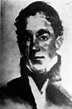 |
| Charles Gratiot - Brigadier General, Chief Engineer, U.S. Army 1828-1838 |
Over time rivers can change quite a bit, carving a new direction into the earth, or flooding, or even drying up. During the nineteenth century the Mississippi River began to change its direction, moving away from the city of St. Louis and toward Illinoistown. This happened when large sandbars formed in the river and the space between the sandbars and the shore began to fill with silt. If nothing was done, St. Louis would be left without a waterfront and transporting goods to the city by the river would become more difficult.
 |
| The north point of Bloody Island. |
 |
| The south end of Bloody Island adjacent to Illinoistown. |
The city of St. Louis finally acted about the growing sandbars in 1833, when it commissioned John Goodfellow to plow up the St. Louis side fill with teams of oxen. After spending more than three thousand dollars on this endeavor they found that the river continued to move away from St. Louis. The mayor asked for government assistance and General Charles Gratiot, Chief of the Army Corps of Engineers visited the city personally. Gratiot decided the problem could be fixed by blocking the river flow between Bloody Island and the Illinois shore. The diverted water would flow westward to the St. Louis side where it would erode Duncan's Island and deepen the St. Louis port.