
 |
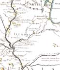
Detail from "Carte de la Louisiane et du cours du Mississip." (map by Guillaume Delisle, 1718) enlarge |
The village of the Illinois was on the edge of the [Illinois] river, on the north side. On the south side, there is a great rock, quite high, and steep almost everywhere except where it comes in a slope down to the water's edge. (René-Robert Cavalier, Sieur de La Salle, 1681)![]()
Beginning in the 1940s, a team of historians and archaeologists from the University of Chicago and the Illinois State Museum sought to rediscover the location of the "Grand Village of the Kaskaskia." The task proved to be difficult, as the geographical references in some French accounts are vague and ambiguous. Nevertheless, careful study of letters, journals, and maps prepared by Jacques Marquette, La Salle, and others suggested that Fort St. Louis had been constructed atop Starved Rock and that the Kaskaskia village was situated on the opposite bank, about two kilometers upstream.
![]()
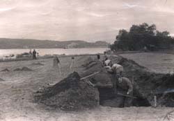
Archaeological excavation at the Zimmerman site, 1947, looking southwest toward Starved Rock.
Archaeological excavations conducted in the late 1940s at the proposed location of the Kaskaskia village, the Zimmerman site, confirmed the presence of an historic Native American occupation that is probably affiliated with the Illinois. Meanwhile, excavations on Starved Rock uncovered not only the remains of Fort St. Louis, but also a long series of prehistoric Native American occupations. Elsewhere, archaeologists have identified the probable locations of two other Illinois villages that were visited or noted by Marquette and Jolliet in 1673: a Peoria village on the Des Moines River in northeastern Missouri (Haas-Hagerman site) and a Michigamea village on the Black River in northeastern Arkansas (Grigsby site).
In Illinois, archaeologists have investigated a number of Illinois villages dating from the late 1600s to perhaps as recently as the early 1800s. Most sites are the remains of summer villages that were mentioned in contemporary documents (Zimmerman, Hotel Plaza, Starved Rock, Guebert, River L'Abbe Mission, and Waterman sites). One evidently was a winter village that may have been visited by a party of Quebec priests who canoed down the Illinois River in the winter of 1698 (Naples site). Others are undocumented locations where Illinois human remains likely were buried (Jamestown and Fort de Chartres III sites).![]()
|
|
Copyright © 2000 Illinois State Museum