Camp DuBois and the Changing Rivers
The Changing Rivers
Lewis and Clark and their men had to work very hard against the current of
the Mississippi to fight their way upstream to Kaskaskia and Cahokia. They
made only ten miles a day in the late autumn. Why was it such a struggle?
The Mississippi River from St. Louis to Cairo is wide and fast-moving. It is full of mud, trees, and debris churning at a fast pace. Charles Dickens was moved to describe it in 1842 as:
“An enormous ditch, sometimes two or three miles wide, running liquid mud, six miles an hour: its strong and frothy current choked and obstructed everywhere by huge logs and whole forest trees: now twining themselves together in great rafts, from the interstices of which a sedgy, lazy foam works up, to float upon the water’s top; now rolling past like monstrous bodies, their tangled roots showing like matted hair; now glancing singly by like giant leeches; and now writhing round and round in the vortex of some small whirlpool, like wounded snakes.”
— Dickens, Charles. American Notes….
Diagram of the channel and floodplains at the confluence of the Missouri
and Mississippi Rivers, 1800
Click image to enlarge.
The channels of the Mississippi River and the mouth of the Missouri River changed every year, creating and destroying islands, channels, and points. The main channels of the rivers sprouted many smaller channels, separated by ephemeral sandbars, islands, and points. The mouths of the creeks and smaller rivers entering the Missouri and Mississippi Rivers were intermittently clogged with silt.
There were large annual floods before modern flood control methods (dams, locks, dredging). In 1800, farmers settled on the drier and timbered bluffs, which are about two miles from the river in the Camp DuBois area. The lowlands near the river were swampy and often flooded. [map adapted from Fig. 2.9, Oliver in Milner, p.38.]
Locating Camp DuBois
One question related to the Lewis and Clark Corps is “exactly where
was Camp DuBois?” How do we know where the camp might have been?
In Clark’s journal of December 12th, 1803, he writes about traveling to the Wood River from Cahokia. His navigation Remarks for December 12th are as follows:
Course |
Time |
Miles |
Remarks |
N.13° E |
2 15 |
2 ¼ |
To pt. On Lbd. Side above a Settlemt. –psd. The upr. Pt. Of the Isd. (1) opst. Is the Lowr. Pt. On Isd. Stbd. Side |
N. 22 E |
2 20 |
6 ¼ |
To pt. On Lbd Side – psd. Creek (2) aboe the high Land. (3) psd. An Island abe. On Lbd. Side (4) psd. The upr. Pt. Of the Isld. On Stbd. – |
N. 3° E |
1 40 |
2 ¾ |
To the mouth of Wood Creek on Stbd Side (5) passd. Sm Isd. On Stbd. Sd. And Landed in the mo: of Wood Creek (6) a violent wind, &c. |
Total |
6 15 |
11 ¼ |
In a letter to his brother-in-law, William Croghan, on January 15, 1804 Clark locates the camp:
“My situation is as comfortable as could be expected in the woods, & on the frontiers; the Country back of me is butifull beyond description; a rich bottom will timbered, from one to three mile wide, from the river to a Prarie; which runs nearly parrilal to the river from about three miles above me to Kaskaskia and is from three to 7 miles wide, with gradual rises and several streams of running water, and good Mill seats; This prarie has settlements on its edges from Kahoka within three miles of this place. The Missouri which mouths imedeately opposet me "is a large turbalent" is the river we intend assending as soon as the weather will permit. This Great river which seems to dispute the preeminence with the Mississippi, comes in at right angles from the West, and forces its great sheets of muddy ice (which is now running) against the Eastern bank.” (Jackson, p. 164)
View the map of the camp area at the confluence on the Beinecke Library Web site at Yale University.
Clark describes the quality of the area of the mouth of the Wood River in an undated journal entry around May, 1804:
“ The Country about the Mouth of the Missouri is pleasant rich and partially Settled. On the East Side of the Mississippi a leavel rich bottom extends back about 3 miles, and rises by Several elevations to the high Country, which is thinly timbered with Oake &. On the lower Side of the Missouri, at about 2 miles back the Country rises gradually, to a high pleasant thinly timbred Country, the lands are generally fine on the River bottoms and well Calculating for farming on the upper Country.” (Moulton, p. 218
Mapping It Out
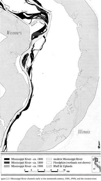
Map of the confluence of the Mississippi and Missouri rivers in 1800,
1880, and and 1908.
Illinois State Museum
Click image to enlarge.
On Lewis and Clark’s 1814 Map of the west (image above), they located
their winter camp on the Wood River. If juxtaposed with a map created by superimposing
old explorers” maps on a modern topographical map of the area (ISM –
Oliver), one can estimate the location of the camp (North is on the left).
Soil samples also helped to document the changes in the rivers. According
to this evidence, Camp DuBois was on the Illinois side of the Mississippi
River in 1803, probably under the current channel of the Mississippi near
the point where the large island is shown.
(Read more about the changing river in Milner.)