The Public Domain Lands in Illinois, 1813-1870.
Poster presented at the:
ESRI users conference, Redlands California, May 1994;
1995 Midwest/Great Lakes ARC/INFO User Conference, Champaign, Illinois,
September 27-19, 1995.
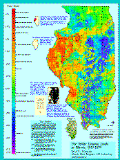
The Project
The Illinois State Museum has made several efforts in
integrating
19th-century documents and ARC/INFO. One of these has focused on
Illinois land records produced at federal land offices and computerized
by the Illinois State Archives. By relating the legal location recorded
in the land office documents with information digitized from modern
topographic maps it is possible to produce various maps reflecting, for
example, earliest or last date of entry per section, or average date per
section.
Since the pattern of land entries reflects the spatial pattern of
frontier development and settlement, this application of the data allows
a view of the history of Illinois never before possible. However, the
specific patterns in a particular area (and at a particular time) are the
results of an interplay of social, ecological, economic, and legal
dimensions. Although the subject is a bit large for this poster, there
are several basic themes visible here.
- At every time from 1813 to the 1870s settlers did their
best to avoid prairie, or at least settle on land as close
to timber as possible. You can see this tendency by comparing
the distribution of timber shown in the small insert with the
distribution of land entries.
- The large area of apparently early settlement in the western
part of the state is an area called the Military Tract. See
the text box at the top of the Time Scale.
- The areas of checkerboard patterns reflect grants given by
the Federal government to the Illinois and Michigan Canal
Company in the 1820s, and to the Illinois Central Railroad
in the 1850s.
We are continuing to improve on this data set, and have completed
some modeling efforts based on selective overlays of the land record
data on other spatial variables.
The Public Domain land records for Illinois, are online at
the
the Illinois State Archives.
SCHROEDER, Erich K., GIS Lab, Illinois State Museum-RCC, 1011 East
Ash St., Springfield, IL 62703; erich@museum.state.il.us
eks, October 19, 1994
© Illinois State Museum -- Last updat
ed 14-Nov-00 by Erich Schroeder
