
 |
|
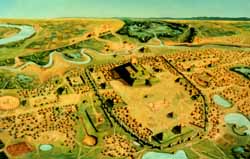
A birds-eye view of Cahokia about A.D. 1100. The center of the community, including the grand plaza, was surrounded by a log stockade. Monks Mound stood at the north end of the plaza. Painting by William Iseminger used by permission of Cahokia Mounds State Historic Site. |
Cahokia
Ancient Cahokia is located on the boundary of St. Clair and Madison counties, just east of East St. Louis, Illinois. Cahokia has long been the subject of archaeological study. The first archaeologists were drawn to the site by its enormous earthen mounds and the possibility that they held tombs with extraordinary objects. Archaeologists working at the site for the last fifty years have been interested in answering more complicated questions. For example, when and how did Cahokia become a city? How did Cahokians construct the large mounds and why? What was daily life like? What was the government of Cahokia and what were Cahokians’ beliefs? And, why did the residents of Cahokia vanish after a few centuries. Archaeologists have carefully excavated a small proportion of Cahokia in their search for answers to these questions. Here is a look at what they have learned.
Nine hundred years ago, Cahokia was a sprawling city, home to perhaps 5,000 or more people. The city was a series of neighborhoods, each with a prominent flat-topped mound on which rested the residence of an important citizen. The city center was enclosed by a log stockade. Upright logs, perhaps 20 feet tall, were positioned side by side to create an impenetrable wall. Inside the wall was a large open plaza, a few neighborhoods, and several large earthen mounds. Cahokians built an immense mound, called Monks Mound, at the north end of the plaza. This mound rises more than 30 m (100 ft) above its surroundings, and is nearly 244 m (800 ft) wide and 305 m (1,000 ft) long at its base. A large building was constructed at the top of the mound. This was probably the home of the great leader of Cahokia.
Cahokia was the center of a political and trade network of communities scattered up and down the Mississippi River, and perhaps of other Mississippian communities elsewhere. For reasons that are still not entirely clear, Cahokia’s influence faded 700 years ago, and, soon thereafter, the city appears to have been largely abandoned. Some archaeologists believe that the sheer number of Cahokia's residents may have depleted many of the local resources, making it difficult to maintain the city.
Cahokia now is a state park with a magnificent museum. Park visitors have the opportunity to walk among the remaining mounds and climb to the top of the largest mound, Monks Mound, and survey one of the most important and extraordinary Native American communities in North America.
 |
|
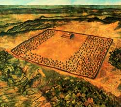
The Larson Site as it may have appeared in A.D. 1100. |
Larson Site and Dickson Mounds
The Larson Site and Dickson Mounds, a large village and a nearby cemetery, sit on the bluffs overlooking the Spoon River and Illinois River valleys in Fulton County. The Larson Site was also a stockaded village with a large flat-topped mound positioned at the end of an open plaza. The plaza was surrounded by rows of houses. Residents of Larson relied on farming corn and beans, cultivating native plants, and hunting, fishing, and gathering food from their resource-rich surroundings.
On a nearby bluff, Woodland and Mississippian people buried the dead in mounds of earth. Now known as Dickson Mounds, this cemetery has been the subject of much study; more than 200 scientific articles have been written about the people who once buried their dead there. Archaeologists and osteologists have learned many things about the Mississippian people who occupied these sites, including how long they lived, how corn affected their health, and how their society was organized.
Dickson Mounds Museum provides visitors the opportunity to explore Native American life in this part of the Illinois River valley. Visitors see displays of artifacts representing prehistoric and historic Native American cultures, a video program on the history of Native American life in this area, and an extraordinary audiovisual presentation on Mississippian beliefs.
Millstone Bluff
Millstone Bluff is located in Pope County, in the Shawnee National Forest in southern Illinois. On the crest of this high hill, Mississippian people constructed a village. Archaeologists from the U. S. Forest Service and Southern Illinois University have found the remains of rectangular houses situated around a small plaza. Nearby, the images of birds and other designs have been found carved into natural rock exposures. These 900-year-old petrogylphs provide insight into the beliefs of the people living at Millstone Bluff.
Millstone Bluff is open to the public. Signs guide visitors along a path and describe what archaeologists have found at the site.
|
|
Copyright © 2000 Illinois State Museum