Physical Environment:
Geology
The Kankakee Flood and Glacial Lake Wauponsee
The outlet through the Marsielles moraine was inadequate to accommodate this pulse of additional meltwater (Ekblaw, et al. 1925). Water backed up behind the Marseilles moraine, flooding across the uplands and creating several large proglacial lakes, including Lake Wauponsee which covered a large part of the Midewin site. Lake Wauponsee reached a maximum depth of 100 feet, but persisted for a relatively short period of time before draining into the Illinois River valley (Willman, 1971). Large segments of the Minooka moraine were washed away, giving it a truncated appearance on the map. The Rockdale moraine was also mostly covered by water during this episode, with the exception of a few high points, which remained as islands in the proglacial lake (Willman, 1971). The Rockdale moraine is a prominent feature at the Midewin site.
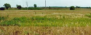 |
| Rockdale Moraine Midewin NTP |
As the floodwaters spilled through (and eroded) the gaps in the Marseilles moraine and into the Illinois River valley, the lake levels were rapidly lowered. At that point, the floodwaters down the Kankakee were very intense, moving boulder sized pieces of dolomitic bedrock and depositing them along the valley. The sand deposited at the Midewin site has a direct and patterned effect on the prairie vegetation. It was probably during this time that areas seen as bedrock on the glacial geology map along the Kankakee and near the confluence of the Kankakee and Des Plaines were exposed by the churning floodwaters. It is in these areas, where the bedrock is within about 15 inches of the surface, that dolomite prairie occurs on the Midewin site.
Next | Back