Native American Mapping Traditions
Native Americans had different mapping traditions. Their traditions were not based on the precise measuring of physical space. They were based on how much time it took to travel, what happened along the way, and what was important to remember about places. The maps were narratives that reflected the seasons of the year and events. Some of the maps were histories of the people.
Lewis and Clark did not always understand the premise of Indian maps. They were interested in the physical design of the maps, but not the conceptual design. In their pursuit of the physical aspects of the land, they ignored the significance of the land to Native peoples.
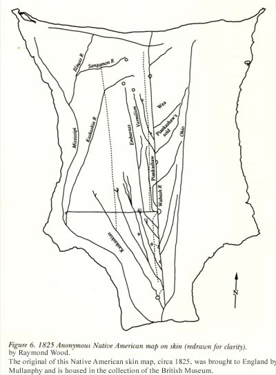
Drawing from a Native American skin map, circa 1825
Raymond Wood
Illinois State Museum
Click image to enlarge.
Forms of Indian Map
Lewis and Clark were making maps for use by the American government
and future settlers and traders. They provided records of land features, to
be filled in with details as they were learned. The maps of Native Americans
were conceptual and historical. Native Americans made some tangible maps,
but they were often ephemeral in form. In 1810, when talking to Nicholas Biddle,
Clark said that “Indian maps made on skins or mats may be given to you,
by individuals, but are not kept permanently among them. Sometimes in sand,
hills designated by raising sand, rivers by hollows, etc.” (Jackson,
v.1)
The form of map Clark was describing was a drawing or diagram etched in sand on the ground. The sand was piled up to indicate hills, and dug down for river channels or trails. Landmarks such as large boulders or villages were indicated. After the conversation or relay of information was complete, the maps were left to erode away.
Another form of Native American map was drawn with charcoal onto an animal skin, which was a more permanent type of map. The landmarks drawn on the map, however, may have had a different meaning for Native readers than they would have for Lewis and Clark. The Corps leaders may have seen a location of a village, whereas the mapmaker may have been drawing the center of their universe.
Lines on the Indian map often looked alike, but could indicate rivers, game trails, or war routes. Note the uniformity in distances and form of all the small tributaries flowing into the main streams on the map above. It is highly unlikely that this uniformity existed in nature. The format illustrates a narrative of travel in the area. The sequence of rivers and creeks is clear, but the evenness of distances between them may not correspond to nature. Nor does the uniform direction or angle in which they flow relative to the main streams correlate with physical reality. Unlike the maps that Clark created, they were not superimposed over a uniform grid.
Indian maps were not always oriented with north at the top. Often they were organized by sunrise to sunset or according to the origin and destination of the journey. Distances were relative — not spaced on a uniform scale of measurement, but by the time it took to travel each segment. Many western Indians did not travel regularly by river, so their calculations were made on distances over land. The Great Falls of the Missouri, for example, were located correctly, but the difficulty of passage for the Corps’ boats was underestimated by the Indians because it was based on their own experience travelling it on horseback, not dragging boats and bulky equipment.
The Native American makers of the maps used verbal explanations to convey their meaning to Lewis and Clark. Lewis and Clark crosschecked information garnered from the Indians about the land and waters ahead. After gathering information from several sources, they incorporatedthe most solid information they received into their own maps . The complete mapping of the Missouri and Columbia Rivers could not have been so complete had Lewis and Clark not had access to the local information of Native Americans. (Ronda, 1984)
Other Native American Mapping Traditions: the Sky Map
Another mapping tradition used by the Plains tribes was the sky chart. The
Pawnee, Arikara, and Wichitas may have adopted this concept about 1,000 years
ago as they traded with the peoples of Mexico and the Southwest. Pawnee star
maps are found on skin shields of the eighteenth and nineteenth centuries.
According to the research of Marhus (1997), these maps may have been used
to teach someone the constellations or used in ritual.
Instead of measuring the location of stars in order to calculate one’s location, asMeriwether Lewis did, Native Americans used the location of stars and constellations to signal seasons and events of the year. For example, the arrival of two stars, the "Swimming Ducks", in the sky over the west signaled that planting time was near. There were other stars related to the summer buffalo hunt and harvest time.
As well as heralding the appearance of the star through the seasons, the chart told the story of the creation of the universe and of the creation of humans. The sky was full of symbolism of the history and cycles of life. This knowledge had been handed down through time. It was used to help determine the arrangement of houses in the village, prepare for hunting expeditions, and guide the people during ceremonies.
Lewis and Clark were not privy to the sacred ceremonies of the Arikaras or
Pawnees and may not have understood the meaning of their references to the
stars.
See the Native American and European Mapping Traditions Lesson Plan in PDF
format.