Read More About It - Coal in Illinois
Illinois' coal occurs in seams (layers). These seams vary from less than 2 centimeters (.75 in.) to more than 4.5 meters (about 15 ft.) thick. About 75 seams have been identified. Each represents a swamp that occurred near the edge of the ocean. When sea level rose, the swamp was flooded and buried by marine sediments. As sea level dropped, a new swamp formed. These changes were related to southern hemisphere glaciation and plate tectonics.
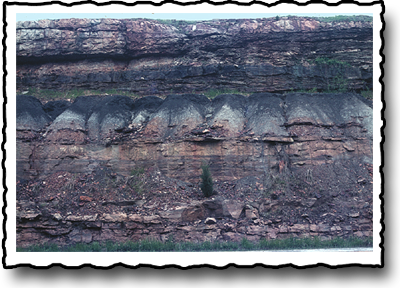
What is Herrin Coal?
Thanks to the Pennsylvanian swamps, dozens of coal seams underlie Illinois.
The major seams have been given names to identify them. The largest is
the Herrin Coal, named for a southern Illinois town in Williamson County.
In 1868, geologists numbered the coal seams by age. Number one is the
oldest. Herrin Coal is number 6. It formed from plants that grew in the
Pennsylvanian swamps between 280 and 320 million years ago. The Herrin
Coal seam averages 2 meters (about 6 feet) in thickness, and underlies
a large part of southern and west-central Illinois. Because of the gradual
down-warping of the basement rock, it’s near the surface in some
areas and buried as deep as 365 meters in others (that’s about 1,200
feet deep).