Underwater Illinois: Read More About It
Earthquakes in Illinois
Around 550 million years ago, the central part of the North American Plate was fractured by stresses caused by shifting continents. Since then, these fractures, known as faults, have been subjected to pushing and pulling as the North American Plate drifts across the globe. Relief of stress in these areas results in earthquakes.
Have Large Earthquakes Occurred in Illinois?
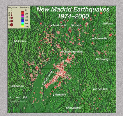
The New Madrid fault zone extends from Cairo, Illinois, 241 kilometers (150 mi.) south to Marked Tree, Arkansas. It averages over 200 earthquakes per year and produces the most earthquakes in the United States east of the Rocky Mountains. In 1811–1812, several very large earthquakes took place here. Land rose or fell as much as 6 meters (about 20 ft.). Some accounts note that the Mississippi River flowed backwards. Entire islands disappeared. Waterfalls and rapids appeared in the river. Some geologists think the New Madrid earthquakes of 1811–1812 represent some of the largest releases of seismic energy in the world.