How Did We Get This? --
The Lake - Climate and Geology
Climate
The climate in 1673 was slightly cooler than the present-day climate.
It is estimated that an average high temperature of
13.4º C.
(56º F), and an average low temperature of 2.8º C. (37º F).
There were 160-170 frost-free days. The average annual precipitation
was 87.1 cm. (34.3 in.).
Geology
In the Late Pleistocene, a series of ancestral lakes occupied the Lake
Michigan Basin. Lake levels ranged from much higher to much lower than
today. Levels were determined by glacial actions, the rebound of the
Earth's crust when the weight of the ice was removed, and by downcutting
of the lake’s outlets.
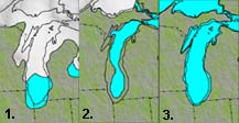
Map 1. When glacial ice was retreating from the Chicago region, the water level was as much as 60 ft. higher than today. Much of the Chicago area was under water. At first, meltwater pooled between the ice and moraines. Erosion cut through the moraines. The lake drained south through what is now the Illinois River valley.
Map 2. As the ice continued to melt, a northern outlet with lower elevation opened up about 12,000 years ago. The continental crust was still depressed from the weight of the glaciers. Lake levels fell up to 262 ft.. The shore was about 31 mi. out into the lake basin.
Map 3. Over the next 4,500 years, the land rebounded. The elevation of the northern
outlet rose, and lake levels rose, too. The Chicago area was underwater
again. A coastal bluff formed in the glacial moraines along the shore.
The lakeshore was about 1 mi. inland. Sand carried by
waves (from glacial deposits to the north) began building up in this
area.