Quaternary Deposits in Illinois.
|
Quaternary Deposits in Illinois.
|
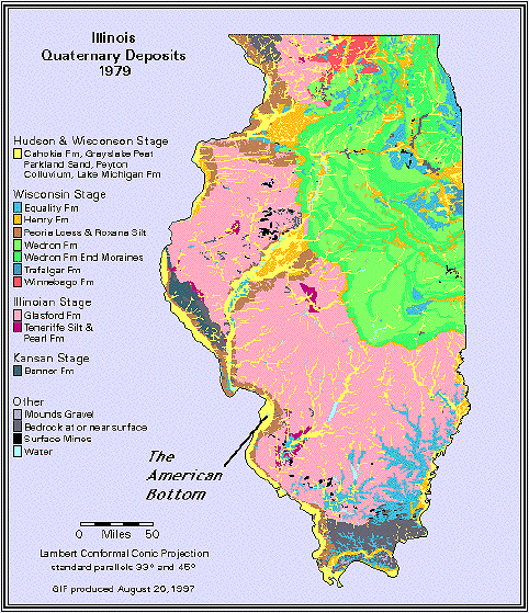
Again, location played an important role in giving the American Bottom its character. First, the American Bottom is located just south of where Pleistocene glacial advances halted. Like a huge conveyer belt, the continent-size ice sheets unloaded massive quantities of water and sediment into the Missouri, Mississippi, and Illinois River valleys. Second, these great midwestern rivers begin to join just north of the American Bottom. After flowing through the comparatively narrow, limestone-constricted valley above Alton (in the Lincoln Hills physiographic Section), the Mississippi River spreads out (in the Springfield Plain physiographic Section) and thus slows somewhat, permitting the deposition and accumulation of deep alluvial sediments. |
This deep and complex suite of alluvial and glacio-fluvial sediments includes coarse-grained channel deposits, sand and gravel point bars, fine-grained fluvial overbank deposits, old natural levees, and a variety of clay-rich swamp, slough, and backwater lake deposits. These deposits are largely part of the Henry and the Cahokia Formations (including Cahokia alluvium, and Grayslake peat). At the bluff margins wind blown dust (created by the ice-sheet grinding rocks into small particles and depositing massive volumes of the resulting silt at the glacial terminus) accumulated to form the Peoria Loess and Roxanna Silt Formations during the Pleistocene. Veneers of colluvium and alluvium (the Peyton Colluvium) washed from the surrounding bluffs and uplands also formed at the bluff-floodplain interface in the Late Pleistocene and Holocene.