erich@museum.state.il.us
Erich Schroeder
Illinois State Museum
GIS Lab
Springfield, IL 62703
Fri May 31, 1996 (based on input from Chris Ferrier (clf@primenet.com)
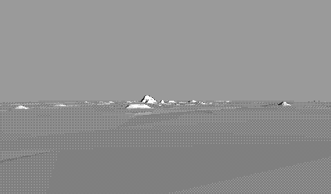 If you are using Netscape 2.0 or better you
are seeing a GIF animation of a vrml scene of Cahokia. To view it you may
reload it, or download it to view as a local file.
If you are using Netscape 2.0 or better you
are seeing a GIF animation of a vrml scene of Cahokia. To view it you may
reload it, or download it to view as a local file.
My goal has been to create an easy method to move from Arc/Info TIN (Triangular Irregular Network) format into VRML. I figured that this should be possible because both are based on nodes, lines, and faces.
It turns out that ESRI is planning to provide a VRML generator with A/I Rev. 7.1! I will probably continue with this although it may prove to be unecessary in the future.
I have only tested it with VRweb running on LINUX. (there have been problems in the browsers I've used under MS-Windows) Hope it works for you, but I don't guarantee it yet.
&r tin2wrl <tin>Where <tin> is the name of a previously-created Arc/Info TIN. Tin2wrl.aml runs two INFO programs.
Arc: items polynodes

COLUMN   ITEM NAME        WIDTH OUTPUT  TYPE N.DEC  ALTERNATE NAME     INDEXED?
    1  TNPOLY#                4     5     B      -                        -
    5  NODE1                  4     5     B      -                        -
    9  NODE2                  4     5     B      -                        -
   13  NODE3                  4     5     B      -                        -
   17  ENDNODE                4     5     B      -                        -
     **  REDEFINED ITEMS  **
    1  RPOLY#                 4     5     B      -                        -
    1  LPOLY#                 4     5     B      -                        -

Arc:
And the files that you will created are called: LPOLYNODES, RPOLYNODES,
POLYNODES, TMPPOLYNODES, and TMP2POLYNODES. They are all the same so
you can just DEFINE one and copy them using the COPYINFO command in ARC .
I imagine that in later versions I will make them real scratch files and
the user will not have to define them. Currently there are lots of debugging
messages displayed as the program runs.
In case you are a sane person (that is, one who is unfamilar with the strange and awkward world of INFO programming), I've put together a description of how to move the text versions of INFO programs into a compilable (hopefully) INFO program.
This interactive aspect of GIS is an continuation of my interest in animation of spatial information, and the representation of time. You might want to look at the under construction exhibit based on the Illinois Land Records, where I have several methods for displaying a series of time slices.