 When Roads Had
Names
When Roads Had
Names30  1921 road map of Illinois To see close-up, click on the top, middle or bottom third of map. |
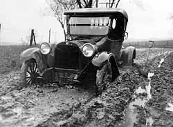
Between 1918 and 1925, over 850,000 new automobile licenses were issued in Illinois. Most roads were deeply rutted dirt tracks that became impassable when wet. The growing number of motorists and farmers needing to move their crops quickly to market pushed for road improvements. This map shows areas where a hard, oiled road had replaced a dirt surface in 1921. Roads were identified by geographic or other names and distinctive symbols before 1926, when the current federal numbering system was devised . 29 |
![Button Bar [8k]](/exhibits/athome/images/1920/buttonbar-h-1920-32.gif)
© Illinois State Museum 31-Dec-96