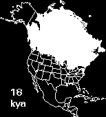
Melting of the Laurentide Ice sheet from its
glacial maximum to about 8,000 years ago.
|
Melting of the Laurentide Ice sheet from its glacial maximum to about 8,000 years ago.
|
Although there appears to be a recent pollution-driven trend to global warming,
the last 2 million years of earth history are known as the Ice Age. This long
period of colder climates is referred to as the Quaternary epoch by geologists.
During this time glaciers throughout the world (especially those in the
Northern Hemisphere) have alternatively expanded and contracted, due to
periodic wobbling of the earth's axis, changing aspects of the earth's orbit
around the sun, and shifting locations of warm and cold water ocean currents
(HDYK-ENV). In North America several cycles of Laurentide Ice sheet advance and
retreat played a major and dramatic role in shaping landscapes from present-day
New York City through Illinois to Alaska. During the coldest part of the last
glaciation about 18,000 to 20,000 years ago, the Laurentide ice sheet reached
its maximun southern limits and stretched from present-day Long Island, New
York (itself a terminal moraine), through flat fields of central Ohio, Indiana,
Illinois and Iowa (HDYK-ENV).
|
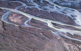
Braided channel on outwash plain of a modern glacier. As glacial retreat continued, river levels lowered, channels erroded and became incised into older deposits, and new floodplains were formed. This left old terraces (floodplains of older, more elevated rivers) perched at higher elevations along valley walls. |
At times, water levels were so high that icebergs broken from the glacier
terminus to the north (in central Illinois, Iowa, and Wisconsin) floated up
Mississippi tributaries depositing exotic sediments scraped by the glacier from
land far to the north. At times so great was the volume of water being
carried, that the Mississippi River blocked the flow of tributaries causing
even major rivers like the Illinois to flow upstream!
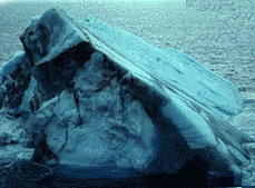
Small, sediment-rich iceberg floating near glacial terminus. |