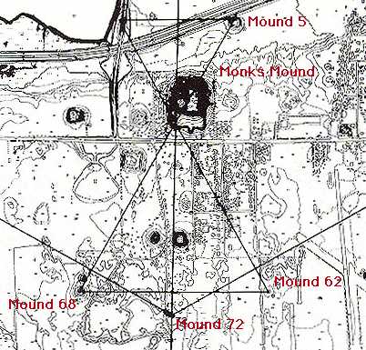
Map of the central section of Cahokia, showing the convergence of axes at the southwest corner of Monks Mound and Mound 72, which bears witness to the planning of the layout (according to solstice events) of many mounds.
Fowler, M. L., Archaeological Research Laboratory, University of Wisconsin-Milwaukee. SEE ALSO Fowler, M. L., 1997 The Cahokia Atlas: A Historical Atlas of Cahokia Archaeology. revised edition. University of Illinois, Urbana. Fig. 6.31, p.144
Image courtesy of M. Fowler.