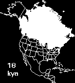
Animation showing retreat of Laurentide Ice sheet (white areas are ice, blue areas represent proglacial lakes).
E.K. Schroeder, Illinois State Museum-RCC, GIS Laboratory.
You can browse the archives for this section.
Animation showing retreat of Laurentide Ice sheet (white areas are ice, blue areas represent proglacial lakes).
E.K. Schroeder, Illinois State Museum-RCC, GIS Laboratory.