Click image to view enlarged version.
The Terrain of Illinois
This section will include information about the flat and hilly areas of Illinois. The southernmost tip of Illinois and the far northwest and western edges of the state still have pre-glacial terrain, where forests grow.
The terrain of the rest of Illinois was altered by the four glaciers that flowed and stayed over Illinois during the Ice Ages. The glaciers brought rocks and other debris to Illinois from Wisconsin and Canada and deposited them when they melted. Some of the lighter deposits were blowed by winds to cover even more of the state. The vast prairies described by pioneer settlers was so flat in some areas that points thirty miles apart aried in elevation by only eight inches.
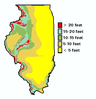
The map to the right illustrates the depth of loess blown across the state. Notice that the deepest deposits are along riverbeds.
The terrain of Illinois was written about and speculated upon by French explorers and English settlers.