 Piggott's
Ferry
Piggott's
Ferry
 |
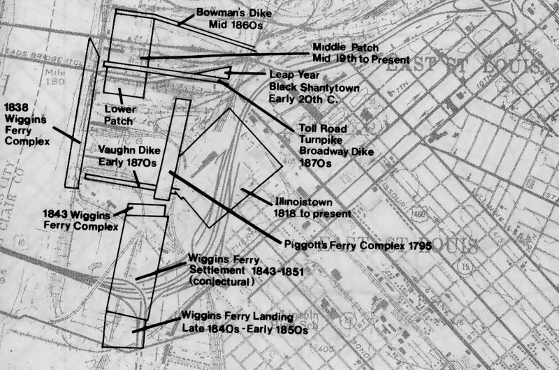
| Map showing historical development of the East St. Louis
waterfront over 200 years. From Gateway to the Past, Illinois Department
of Transportation, 1982. |
James Piggott, a late eighteenth century pioneer and a territorial judge
for Illinois, settled in the American Bottom region of Illinois after migrating
from the Eastern United States. Once settled in Cahokia, Piggott
and his family built a log and mud road from that settlement to a point
on Cahokia Creek opposite St. Louis in 1792. During that time the
area that is present day East St. Louis was swampy and uninhabited.
Goods crossing the river from the Illinois side had to travel from Cahokia,
upstream to St. Louis. Piggott's road allowed him to move goods onto
Cahokia Creek, into the Mississippi, and across the river to St. Louis.
This access was more direct than shipping from Cahokia and Piggott soon
had a growing business providing access to St. Louis.
Branching Out...
Before steam, coal, or diesel powered large ships, human or animal power
was necessary to move goods and people across the Mississippi. James
Piggott and those that followed him used pirogues, flatboats, and keelboats
for forty years before reliable steam boats plied the river. Follow
this link to learn more. |
|
Once established Piggott refurbished the route to Cahokia Creek with
a sturdy road consisting of rocks buttressed with logs through the swampy
region. Cahokia Creek, not wide or deep enough for regular use, quickly
became an obstacle to Piggott. He spanned a 150-foot wooden bridge
over the creek to the river front where he built two log cabins.
Piggott's Ferry became a central point for travelers and soon the area
further inland began to be developed.