ST. LOUIS CITY PLAN COMMISSION - 1969
Physical Growth of the City of Saint Louis
INTRODUCTION
COLONIAL PERIOD: 1764 - 1804
TERRITORIAL PERIOD 1804 - 1821
BOOM TOWN: 1821-1861
CIVIL WAR PERIOD: 1861-1865
THE GOLDEN AGE: 1865-1900
WORLD'S FAIR PERIOD: 1900-1914
WARS, PROSPERITY, DEPRESSION: 1914 - 1945
MID 20th CENTURY: 1945-1968
BIBLIOGRAPHY
CHRONOLOGY
The Mississippi River and its valley were first explored by the Spaniard, Hernando de Soto in 1542. However, Spain made no effort to establish its sovereignty in the valley.
French claims to the valley began following the expedition of Marquette and Joliet in 1673, who came into the Mississippi from the Wisconsin River. The first settlements were made by LaSalle on the Illinois River near what is now Peoria and at Starved Rock. They were administered by LaSalle's captain, DeTonty.
Cahokia, founded in 1699, was the earliest French settlement still in existence. Next to be established was Kaskaskia, which was followed by a series of east bank towns at Prairie du Pont, Fort Chartres and Fort Vincennes on the Wabash. Settlements by the French on the west bank of the Mississippi included Ste. Genevieve and New Madrid (then known as Ainse de la Graise or "Greasy Bend"). These were followed by St. Louis, St. Charles, Carondelet in 1767, St. Ferdinand (now Florissant) and Portage des Sioux.
Upon returning to Fort Chartres following his first visit to the present site of St. Louis, Laclede said:
PIERRE LACLEDE 1764, "I HAVE FOUND A SITUATION WHERE I AM GOING TO FORM A SETTLEMENT WHICH MIGHT BECOME, HEREAFTER, ONE OF THE FINEST CITIES IN AMERICA --SO MANY ADVANTAGES ARE EMBRACED IN ITS SITE, BY ITS LOCALITY AND CENTRAL POSITION, FOR FORMING SETTLEMENTS . "
The City of St. Louis is in its present location because the founder of the City, Pierre Laclede Liguest, chose this site to establish his fur trading post so it would not be subject to flooding, yet would have a central location.
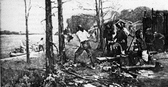
This site was found when, in November, 1763, Laclede and his band of traders from New Orleans landed at what is now the foot of Walnut Street. Here was a high limestone bluff rising about forty feet above the Mississippi, sloping back in two or three terraces to the west and extending about two miles along the riverfront. This bluff and the receding terraces were covered by a growth of timber extending irregularly west as far as present day Fourth Street. Beyond this point, a broad rolling prairie containing infrequent clumps of timber reached to the horizon. A small creek flowed into the river below the selected site; it traversed a wooded valley across the prairie from the west. Affording a place for the erection of a mill and dam, the creek later was called Mill Creek and formed Chouteau's Pond. Its valley marked the south end of the bluff along the riverfront.
Upon choosing the site for the trading post, Laclede declared that, "This settlement will become one of the finest cities in America." After wintering at Fort Chartres, Laclede sent his lieutenant, young Auguste Chouteau, and thirty men to clear the site in February, 1764.
The first structures erected included a large house for the fur company's headquarters, cabins for the men and a storage shed for provisions and tools. The post house, completed in September, 1764, was located on the block once bounded by Market, Walnut, First and Second Streets which is now part of the Jefferson National Expansion Memorial Park. The house became the nucleus around which the village was built and also the focal point for all measurements locating lots and streets.
As laid out by the French, the village contained three north-south streets, La Grande Rue (Main Street), Rue d'Eglise (Church Street) and Rue des Granges (Barn Street); now First, Second, and Third Streets. There were several narrower east-west streets including La Rue de la Tour, Rue de la Place and Rue Missouri; now Walnut, Market, and Chestnut Streets. In addition to the block for the post house, squares were set aside for a church and a public place. A fort was built on the hill overlooking the village, at what is now Fourth and Walnut Streets.
Laclede's decision to expand the post into a village was made following receipt of news that France had transferred the land east of the Mississippi to Great Britain. French settlers in the east bank villages of Cahokia and St. Philippe speedily moved to the new settlement on the west bank, causing it to expand immediately into what came to be known as Laclede's village. However, the official name of St. Louis was given to the village by its founder in honor of the Crusader King, Louis IX of France.
The original lots were assigned by Laclede verbally to the first arrivals who had come to stay. The lot selections were generally along the riverfront to be near water, since the colonists soon learned that the whole site was underlaid by a deep bed of limestone with very few springs. About forty settlers located here in 1764, preceding a much greater number in the following year, during which the greatest building activity occurred. Many brought parts of their former homes from the east side of the river.
The custom of making land grants verbally continued until 1766, when Captain Louis St. Ange de Bellerive, the French Lieutenant Governor arrived and established administration of the settlement's affairs. He required the land grants to be recorded in the "Livre Terrien" or Register of Deeds. Thus custom was continued after the Spanish obtained dominion over the territory in 1768 until the Louisiana Purchase in 1804. In 1766, the settlement consisted of 75 buildings and about 300 inhabitants. The design of the village followed the French town system which provided for a town on a small tract divided into small square blocks, each block individually owned by a "habitant."
After assignment of the town lots, the next step was to provide a "Commons" or open field for the grazing of live stock. A well wooded and watered tract of land southwest of the settlement was set aside for this purpose. This area is presently bounded by Fourth Street, Clark Avenue, Tenth Street, and Park Avenue. It contained the site of Chouteau's Mill and the eastern portion of Chouteau's Pond. The commons were not owned individually, as the title was vested in the town as a corporation. In later years a much larger commons was laid out, reaching west to what is now Grand Avenue and south to Meramec Street.
Another basic problem was the provision for land suitable for cultivation, known as a "Common Field." The common fields were owned by individuals and were long, narrow strips of land laid out side by side. It is said that this design was adopted as a safeguard against Indian attack, enabling the settlers to work the strips in a line, keeping together in a more secure position. The original common field extended from the present Market Street on the south to the large mound at the foot of Mullanphy Street on the north, and from Broadway west to Jefferson Avenue. This tract was divided into farms which were one or two arpents wide (an arpent being 192 feet six inches), with a depth of forty arpents or 7, 700 feet. Today, Jefferson Avenue has a bend at Washington Avenue because south of that point the west line was forty arpents west of the line of the old town, a line which ran southwest; whereas, to the north of Washington Avenue, the line was forty arpents west of a ridge along the river, which ran northwest. As the town grew in later years outlying common fields were established, so that by 1770 its subsidiary lands covered about 25 square miles. The Grand Prairie Common Field was laid out with a ridge along its east side which now corresponds to the location of North Grand Boulevard. Since the field lots were perpendicular to this ridge, the streets which ultimately were laid out in this area follow the old lot lines of the Fields. The Prairie de Noyers Common Field was located southwest of the town with its western limit at what is now Kingshighway. The former Common Fields of Carondelet can be recognized on a map by the bias trend of streets south of Meramec Street.
The houses in the village were built either of stone or of timber posts set on end in the ground. The stone was quarried along the river bluff and because the site was well wooded, timber was in abundance. The stone houses were erected by the wealthier settlers. The architectural style was similar to that prevailing in the South. The houses were one story in height with a loft above and steeply pitched roofs on all sides. The larger ones had porches or galleries all around, others only in front.
The numerous timber structures were built of round posts set about three feet deep; some of the better ones were made of hewn posts about nine inches square set on a stone foundation wall about four feet above ground level. The majority of the houses were about twenty by thirty feet in size, divided into two or three rooms. Some consisted of one large all-purpose room with an outside kitchen shed. The stone houses usually had fireplaces in each room and hand hewn flooring. The first church building was a log structure built in 1776 on the same block now occupied by the Old Cathedral.
Though not spectacular, the village's growth in the latter years of the 18th Century was steady, and the frontier trading post soon became the most important village within a radius of hundreds of miles .
In 1770, at the end of the administration by St. Ange, the village contained 15 stone houses and 100 wooden ones, of which about 75 had been erected during 1765 and 1766. The population numbered 500. A succession of Spanish lieutenant-governors followed St. Ange until the transfer of the territory to American dominion in 1804. The Spanish continued the Livre Terrien for recording land titles.
By 1780 the growth of the village caused the addition of the present Third Street to the town plat. In this same year a British inspired Indian attack occurred in St. Louis, resulting in several casualties among the residents cultivating the common fields.
The fortifications were not maintained or expanded during the Spanish regime, and fortunately no other military engagements took place here. A census by the Spanish Lieutenant-Governor Delassus in 1798 showed that the population of St. Louis had grown to 925 inhabitants.
The secret treaty of St. Ildefonse in 1800 ceded the Louisiana Territory from Spain back to France. This event made no change in the government at St. Louis and was only symbolized by a token period of flying the French flag during the transfer of government from Delassus to Captain Amos Stoddard in 1804, when he took possession of Upper Louisiana for the American government.
The Louisiana transfer left St. Louis land titles in a chaotic state because the concessions by St. Ange and succeeding Spanish governors were not perfected into royal grants. This resulted in their annulment by American authorities, and only those claimants who could prove actual settlement and cultivation got their claims confirmed by a Board of U.S. Commissioners.
In 1804, St. Louis contained 180 houses and was much the same in appearance as it had been for over thirty years. Most of the houses were located on Main Street and Second Street with a few on Third Street. These streets were still known by their old French names.
The town lots were enclosed by wooden fences or stone walls surrounding the entire block. The main street was 36 feet wide, but in some places there was not more than 30 feet across it from house to house. East-west streets were simply lanes about 30 feet wide with few houses facing them. Market Street, west of Main, was little used and contained a low spot between Second and Third Streets. The present Walnut Street was the principal road from the Government house, at its southeast corner with Main Street, to the Fort on the hill. The few stores in the town in 1804 included a bakery, two small taverns, three blacksmiths, and two mills. There was only one doctor. Some merchants such as grocers operated from their homes and carried a general stock at extremely high prices. Coffee and sugar were $2.00 per pound due to excessive transportation costs overland or up river by flat boat.
There were no paved streets at that time nor had any brick yet been made for building houses. Frame houses began to replace log ones after the American occupation began, but the first brick house, for William C. Carr, was not built until 1813.
The Mississippi River was narrow and swift at St. Louis in 1804, the channel being about 75 feet deep. The limestone bluff along the riverfront attained its highest elevation at the present site of Eads Bridge; from that point the bluff sloped gently to Market Street, ending rather abruptly in a fifty foot bank. From there the shore line descended gradually into the alluvial bottom at what is now Poplar Street. At the base of the bluff was a flat rock shelf about 100 feet wide which afforded a low water tow-path from Market Street to about Franklin Avenue. No street fronted on the river in 1804 and the rear yards of houses fronting on Main Street extended to the edge of the bluff. Thus St. Louis had already begun to turn its back to the river instead of making it a beautiful natural asset.
An English visitor to St. Louis in 1806 noted that the town had about 1,100 inhabitants, 300 houses and several mercantile stores. He commented on its favorable climate but felt that the moral standards had dropped after the arrival of Americans from Virginia and Kentucky. The town's first newspaper, the Missouri Gazette, was founded in 1808 by Joseph Charless.
Frederick Billon, who first saw St. Louis in 1809, described the town as virtually unchanged in over forty years. At that time, he said, there were but two roads ascending the bluff from the river at the present locations of Market and Oak (Delmar) Streets. They were abrupt ascents that had been quarried by the settlers for access to the river for water. He further commented that in 1809, Fourth Street south of Elm was a road with only two or three houses.
The "Town of St. Louis" was incorporated by the Court of Common Pleas in 1809. It covered an area of 7.63 square miles and was largely rural in character. In 1811 the built-up section of the town was defined for municipal purposes as extending from the foot of the present Franklin Avenue west to what is now Broadway and south to Mill Creek, thence east to the river. The population then was estimated at about 1,200.
A description of the town in 1811 is contained in Brackenridge's Views of Louisiana. He stated that the town was built between the river and a second bank or bluff, with three streets parallel to the river and a number of others crossing at right angles. He lamented that no space had been left between the town and the river for a promenade, so as to allow no encroachments to the riverfront. He further stated that St. Louis was the seat of territorial government and that "it bids fair to rival New Orleans in importance."
The river lost its narrow aspect at St. Louis after 1804 when a small sand bar formed near the Illinois shore below Bissell's point. It deflected some of the river current against the east bank causing a wash out and subsequent widening of the river as well as the creation of Bloody Island from the sand bar. This trend continued until after 1850 when dykes were built to prevent the channel from completely deserting the St. Louis side of the river.
1816 witnessed the first physical extension of the town through new subdivisions or additions. The population of 3,000 could no longer be confined to the old town "under the hill. " Colonel Auguste Chouteau and Judge J.B.C. Lucas opened the first subdivision "on the hill," extending from Fourth to Seventh Streets and from St. Charles to Spruce Streets. It contained fifty acres and its rectangular blocks were bounded by much wider streets than those of the old town. Prior to 1816, only two houses were west of Fourth Street, both of stone, one being the officer's house in the Old Fort San Carlos and the other built by Judge Lucas in 1812 at Seventh and Chestnut Streets.
North St. Louis was also laid out in 1816, providing for the location of mills which aided in the early business development. It was developed by Chambers, Christy and Wright along the river between the present Tyler and Wright Streets. Several other towns grew up around St. Louis, and in 1821 their combined populations totaled 9,732 persons, with St. Louis containing about 5,500 of this number.
Timothy Flint, a missionary from Connecticut, visited St. Louis in 1816 and was favorably impressed by the view of its white, lime coated buildings as seen from a distance. Flint was of the opinion that the Americans had given the town an economic boost following the War of 1812. Their enterprise stimulated the lead and fur trades and general business activity to such an extent that, he claimed later, over 100 houses were built here in 1818. Flint foresaw the role of the steamboat in the town's growth.
The first steamboat, the "Zebulon M. Pike," arrived in St. Louis from Louisville on July 27, 1817. This liberated river commerce from dependence upon hand-propelled flat boats and made possible easier progress upstream against the current.
By 1818, the town had about 40 stores, a post office, three banks, a land office, a brewery, two distilleries, a steam flour mill, and several water powered mills. In this year, the school which later became St. Louis University was founded. Three years later, steamboats lined the riverfront and the town had become an outfitting point for trappers and explorers of the West.
The first city directory was published in 1821 and included an interesting description of the town as it then appeared:
"Eight streets run parallel to the river and are intersected by twenty-three others at right angles. Streets in the old town are narrow, while those west on the hill are much wider, providing a pleasant and salubrious appearance. The lower end of Market Street is paved and it is to be hoped that soon the trustees will provide for the paving of Main and other streets. On the hill, in the center of town, is a public square donated by Judge Lucas, on which it is intended to build an elegant courthouse. Market Street is in the middle of town and is the line dividing the north part from the south. Those streets running north from Market Street have the addition of North to their names, and those running in the opposite direction, South. The houses were first numbered by the publisher of this directory (Paxton) in May, 1821."
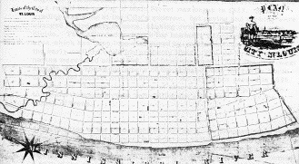
The State Legislature passed an act to incorporate St. Louis as a City on December 9, 1822, with a mayor and nine aldermen. It was divided into three wards. The limits began at the foot of Ashley Street, ran west to about Seventh and Carr Streets, thence south along Seventh Street to Rutger and east to the river, embracing an area of 385 acres. The new City government soon asked its engineer, Rene Paul, to submit plans for street improvements, and as a result the paving of Main Street was begun in 1823. Street grading was done at the City's expense, but paving and curbing were charged to property owners, causing owners of large lots to sub- divide. This afforded a chance for business improvements in an area which had been long disfigured by rustic enclosures built by the early settlers to define property lines. The old French street names were used until 1809, but from then until 1826, the east-west streets were known by letters of the alphabet with the prefix North or South (of Market Street) attached. An ordinance passed in 1826 adopted the Philadelphia system of street names, giving numbers to the north-south streets and calling the east-west ones by the names of trees.
A description of the riverfront in 1825 by E. H. Shepard notes that: "Front Street, or the levee, as it is now called, then had no existence as a street or landing, except as the east end of a few cross streets, but was a serrated limestone ledge of rocks, which formed a part of the enclosures of the blocks east of First or Main Street, from the north line of the City to near the foot of Spruce Street, where it disappeared under the alluvial bottom of Mill Creek, the southern boundary of the City at that period. The formation of this front into one continuous landing, levee or wharf attracted the early attention of Mayor William Carr Lane's mind and he promptly passed it before the public for consideration. The St. Louis public then viewed the project as visionary, and the labor as herculean, unnecessary and impossible, and it required years before those interested in its completion could be persuaded to acquiesce in and willingly aid in its execution. "
In 1827, Congress passed an act authorizing a U.S. Arsenal at St. Louis, and construction began at what is now Second and Arsenal Streets in the same year. The site was then considered remote as it was over a mile south of the city limits, and the only bridge crossing Mill Creek was on the unpaved road to Carondelet. The year 1829 marked the completion of the brick courthouse and the start of a new Market house and city building on the site of the old 1811 Market house in the Place d'Armes at Main and Market Streets.
These events induced many property owners to build new buildings and caused visitors of the time to comment on the many new brick houses and business buildings. This wave of construction obliterated many of the early French landmark houses in the old town, but it also extended to all parts of the City. About this time the City began the paving of Olive and Chestnut Streets from Fourth Street to the river, causing the erection of the first two story row houses, called Kerr's Row, on the north side of Chestnut between Main and Second. Taxes for street improvements increased and stimulated property owners to build, eliminating many vacant lots.
In 1829, Seventh Street was widened to sixty feet and Fourth Street was surveyed as far as Lombard Street. During the same year, several warehouses were built on the levee, and stores were constructed along Main Street, which was becoming the chief business street of the City. This business trend caused some old residences to be converted into stores and the removal of families to outlying locations. Country homes of the wealthy appeared in the vicinity of what is now Eighteenth Street.
The decade from 1830 to 1840 was one of prosperity and growth in the booming river City. The population increased from 6,694 to 16,649. Many new Protestant churches were established, a new Catholic cathedral was erected, the City water works was begun and the public school system was started. In 1840, the cornerstone for St. Francis Xavier Church and St. Louis University was laid at Ninth and Green (Lucas) Streets. The college, opened in 1829, was the first institution of higher learning west of the Mississippi. In 1833, Judge Lucas opened a new addition west as far as Ninth Street, and three years later the Soulard addition on the south side and additions by John O'Fallon and William Christy were opened between Washington and Franklin Avenues. Many new additions opened beyond the city limits, but without control over platting, there was no continuity in the location or direction of streets or in the size of blocks. As a result, streets had jogs, dead-ends and various widths, creating problems which had to be corrected at great expense in later years through widenings and cut-offs. A description of the City in 1837 states that there was no hotel, store, or saloon in the City west of Fourth Street, nor any house over two stories high. The City also lacked a suitable theater, hotel, park, bank, and library. However, the new St. Louis Theater was opened later in 1837 and the foundation for the Planter's House Hotel was laid in the same year. The State Legislature also soon chartered new banks, railroads, insurance companies, a gas company, a chamber of commerce, and a medical society. The City Directory of 1838 reflected the City's prosperity in this way: "Vast numbers of new buildings had caused a significant spread in business locations, thereby changing the complexion of former residential neighborhoods," particularly within what later became the central business district. Third and Fourth Streets began to attract retail operations after 1840 and the City was extending up and down the river as well as westward.
After a minor adjustment in 1839, the city limits were expanded in 1841 to include an area of four and one half square miles. These limits began at the foot of Wyoming Street, ran west to Second Carondelet Avenue (now 18th Street) thence northward to the foot of Dock Street. This expansion included North St. Louis, St. George, Central St. Louis, and a number of other additions. (See page 37)
Steamboat traffic was growing rapidly with westward expansion, and this influence was manifested in St. Louis by the animated appearance of its levee and the start of local steamboat construction. The wharf was partially improved and paved after 1831 when the last vestiges of the stone bluff had disappeared. In 1840, the Mississippi River passed St. Louis in two streams of equal size divided by Bloody Island, now part of East St. Louis. This island was so named because it was the scene of numerous duels.
The current in the stream washing the City's levee was diminishing and threatened to leave the City high and dry if not altered. This resulted in the deposit of much silt below the town, creating Duncan's Island, which impeded navigation to the extent that no steamboat could land below Market Street. St. Louis interests obtained Federal aid and Major Robert E. Lee was sent here to supervise channel work. The work was delayed by owners of town lots in Illinoistown who brought an injunction suit against the operations. This, however, resulted in a better plan which ultimately joined Bloody Island to the Illinois shore by a dyke system. This channel change caused Duncan's Island to be washed away by the strong current on the St. Louis side of the river.
Between 1840 and 1850, St. Louis continued rapid growth, both in area and population. An important factor in the population increase was the influx of large numbers of immigrants, particularly from Germany and Ireland. The Germans, who fled the revolution in their homeland, settled here in such numbers that by the early fifties, the City ordinances had to be translated into German for their benefit. The City's growth was primarily toward the north between 1840 and 1850, but about 1850 a rapid advance took place to the south and southwest. On the north side, the land in Lowell was first offered for sale in 1849 and in 1850 the town of Bremen was organized. After 1850, a westward trend also started, with the opening of Lucas Place in 1851. This was followed by the large Stoddard Addition, west of Jefferson Avenue in 1852. The City began to spread in a northwesterly direction after the opening of the Fairgrounds in the middle fifties.
The park system was begun in 1844 with the purchase of Lafayette Park from the old St. Louis commons, and the transit era opened with the introduction of an omnibus line by Erastus Wells. The City streets were first illuminated by gas in 1846; in that same year the police department was organized, and the Mercantile Library was incorporated. The next year witnessed the opening of the City Hospital, Bellefontaine Cemetery, and Boatmen's Bank, and St. Louis was connected to the East by telegraph line.
St. Louis suffered a severe set back in 1849, a year of disaster. A great fire devastated 15 city blocks along the riverfront and destroyed 23 steamboats. In the same year, the City was visited by a serious epidemic of cholera, which took a toll of thousands. This epidemic led to the draining of Chouteau's Pond in the early 1850's. The pond had long since lost its idyllic rural character of the old days and was polluted by industrial waste. Its valley became the site of the lines and yards of the Pacific Railroad.
At the midway point in the 19th Century, St. Louis entered the last antebellum decade with a population of 77,860, nearly five times the number in 1840. In the early 1850's, the first public sewer was built, and the construction of railroads began. The year 1853 marked the incorporation of Washington University and the first public high school in the City. Two years later, in 1855, several important events took place. The first train of the Pacific Railroad departed for the west and subsequently was wrecked in a disastrous bridge collapse at the Gasconade River. The St. Louis Agricultural Fair was founded in what is now Fairground Park.
The City had expanded so rapidly to the west, that in 1852 the inhabitants of the district between the city limits (then at 18th Street) and Grand Avenue formed a "Second Municipality of St. Louis." By action of the State Legislature, this town, as well as Bremen, Florence, Highland, and other populous districts were added to the City of St. Louis in 1855. These limits, which embraced an area of 13.94 square miles, started at the foot of Keokuk Street on the south, thence west to a line 660 feet west of Grand Avenue and continuing northwardly on this line to Bellefontaine Road and thence northeast to the river near the foot of East Grand Avenue. (See page 37) Expansion continued rapidly into this new area, particularly to the west and southwest. New streets and subdivisions were opened, and it was during this period that many of our present major streets began to assume importance.
Old Manchester Road (now Market Street), the St. Charles Plank Road (now Easton Avenue), Natural Bridge Road, Florissant Avenue, Gravois Avenue, Carondelet Avenue (now South Broadway), North Broadway to Baden developed into main thoroughfares because they were the principal traveled routes leading into St. Louis County. Grand Avenue was laid out along a high ridge west of the City in 1850 by Hiram W Leffingwell and Richard Elliot, pioneer civil engineers and real estate men. The street was intended to be 120 feet wide, but was reduced to the present 80 feet by the County Court in a moment lacking in civic foresight. Lindell Boulevard was the main street platted in the subdivision of the Lindell farm west of Grand Avenue. The Lindell brothers were prominent merchants who made a fortune in the mercantile business and invested it in real estate. The subdivision of their farm into straight wide streets with large blocks was unique at a time when most additions were still conforming to the same old irregularities.
Kingshighway was originally called Rue de Roi by the French and Camino Real by the Spanish. It was a natural north-south connecting road running through farm lands west of town. As mentioned elsewhere, it was the dividing line between old land grants. In 1900, after the City had extended beyond it, Kingshighway was established as a boulevard by City ordinance. Twelfth Street obtained its unusual width in the downtown district due to the presence of the old Lucas market in its center.
In the first few decades of the 19th Century, the business life of St. Louis centered along Main or First Street, between Walnut Street and Washington Avenue. As the City grew westwardly, the business section gradually spread in this direction also. This trend was accelerated by the Great Fire of 1849, which burned out practically the entire area east of Third Street between Walnut and Locust Streets (now in the Jefferson National Expansion Memorial). While the fire destroyed the City's earliest surviving buildings, which were largely of brick and wood frame construction, it created the opportunity for more substantial rebuilding. The structures which emerged following the fire were built with particular emphasis on fireproofing. They were generally four or five stories in height with heavy brick walls faced on the street front with stone or cast iron facades.
As the City spread outward, extended lines of transportation became necessary. As mentioned earlier, the first public transit was an omnibus line established in 1843. It ran from the old National Hotel at Third and Market Streets to the North St. Louis ferry landing at Madison Street. By 1859, which was the last year of their operation, the City had eleven lines of omnibus busses reaching all main points of interest.
The first tracks for horse car lines were laid in 1859 on Olive Street from Fourth to Tenth Streets. This mode of transit became popular due to the smoother ride provided on the rails as compared to riding over rutted and bumpy streets in the omnibuses. Many horse car lines were established in the following years until the network covered the entire built up portion of the City during the seventies. These lines were operated by separate companies and did not provide for transfers.
Parks were another necessity for the complete urban life. The City had made some provision for the recreation of its citizens from its early days, when one of the first blocks in the village was known as La Place Publique or Public Place, bounded by the river, Market, Main, and Walnut Streets. The first public market was erected in this square in 1811, this being the reason for Market Street being so named. The present site of the Old Courthouse was set aside as a public square in 1816. During the subdivision of the old City commons in the 1830's, several small tracts were set aside for perpetual use as parks. These included the present Laclede, Mount Pleasant, Gravois, and Benton Parks, the latter being used as a City cemetery until 1866. The first large park within the city limits was Washington Square, where the City Hall is now located. It was acquired by purchase in 1840 at a cost of $25,000. Carr Square was donated to the City in 1842 by William C. Carr. As noted, Lafayette Park, which had been set aside in the subdivision of the commons for use as a parade ground, was declared to be a park in 1844 but was not dedicated until 1851. It was not fully landscaped until after the Civil War. Among other parks of the antebellum period was St. Louis Place, given to the City by John O'Fallon in 1848 and Hyde Park, acquired by purchase from Anne Farrar in 1854.
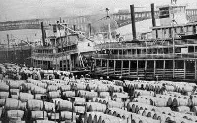
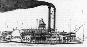
River traffic increased so rapidly that by 1850, St. Louis was the second largest port in point of tonnage in the country, being exceeded only by New York. An English visitor in 1858 was impressed by the levee which "extends along the right bank of the Mississippi for nearly six miles, about half of which length is built upon. " He reported that as many as 170 steamboats had been counted at the St. Louis levee at one time. This was the "Golden Age" of river traffic when some of the finer boats were literally "floating palaces, luxuriously appointed and decorated inside and out with Victorian carpentry.
As river traffic increased, so did St. Louis; during this period, it was the largest City in the nation west of Pittsburgh. St. Louis was a flourishing community when Chicago was only a small town of a few hundred inhabitants on the shores of Lake Michigan. During the development of river traffic, travel by land also began to develop from St. Louis. The City became a terminus for stage coach lines from the east and later was a starting point for similar routes to the west over the Santa Fe and National Trails. The discovery of gold in California in 1849 made St. Louis the outfitting point for many wagon trains heading west.
A new method of land transport, which later sounded the death knell of the steamboat, began to influence St. Louis in the 1850's. The railroads had spread from the east to reach the Mississippi opposite St. Louis about 1850. There was no bridge across the river at St. Louis, so passengers and freight were hauled across by ferries to the City. Construction began in 1852 of the first railroad west of the Mississippi. This line was called the Pacific Railroad and became the nucleus of the Missouri Pacific system. It was built westward to Jefferson City by 1855 but did not reach Kansas City until 1865 because of the War. Soon after the start of the Pacific line, the Iron Mountain Railroad was constructed southwardly from St. Louis to tap the rich mining sections of southern Missouri, and the North Missouri Railroad (later the Wabash) was built to the north and west.
A cultural factor in the growth of St. Louis was the Agricultural and Mechanical Fair, established in 1855 in what is now Fairground Park. Beginning as a small county fair, it gradually grew into a large exposition of more than 100 acres in area with pavilions devoted to the arts and sciences, a zoological garden and a race course. Its reputation became international, and it was visited by American presidents and European royalty. The fair was held in the fall of each year and attracted hundreds of thousands of visitor' to the City, many of whom remained as residents.
In 1860, on the eve of the Civil War, St. Louis had become a mature City having undergone the transition from a town entirely dependent upon river traffic to a commercial metropolis with both river and rail connections. The City's population in 1860 was 160,733, considerably more than double that of ten years before.
When the Civil War broke out, St. Louis was the most important City in the West. The war brought much hardship and suffering to the City, even though the City was not involved directly as a scene of conflict. While Missouri was nominally a slave state, it had generally remained loyal to the Union. A convention was held in St. Louis in January, 1861 to determine the stand of Missouri on slavery and secession; it was voted to keep the state in the Union.
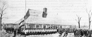
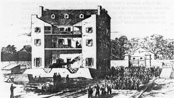
In May, 1861, Camp Jackson, which was near Grand Avenue and Pine Street, was in the hands of southern sympathizers and the state militia under Brigadier-General D.M. Frost. It was then captured for the Union by northern forces under General Nathaniel Lyon. In August, 1861 martial law was declared in St. Louis and several pro-southern papers were suppressed. The U.S. Arsenal here remained in Union hands for the duration of the War.
During the period of the war, the Metropolitan Police system was established in 1861, followed four years later by the creation of a paid fire department. Ironclad riverboats were constructed at Carondelet by James B. Eads, and the Courthouse at Fifth and Market Streets was finally completed in 1862, after having been under construction since 1839.
The war caused many difficulties in St. Louis, such as the cessation of river traffic from the South. This had a severe effect on local business, retarding the City's progress and eventually causing it to lose ground to Chicago in its race to be the leading city of the Middle West. The war reduced the platting of new subdivisions in the City to a negligible level and had a similar stultifying effect on building construction.
With such a backlog, it was obvious that the end of hostilities would see the City's progress resume at an accelerated pace. Nowhere was this more apparent than in the downtown district, where the decrease in steamboat traffic following the War caused the levee to decline in importance.
As a result, there was a westward thrust of the principal axis of the business area. This reached Fourth Street about 1870, and during the period immediately preceding and following the War, this street contained the City's principal hotels, office buildings, banks, and stores. The chief hotels of this period were: the Southern at Fourth and Walnut Streets, which opened in 1865; the Planter's House at Fourth and Chestnut; the Everett House on Fourth near Locust; and the Lindell at Sixth and Washington. The office buildings were concentrated near the old Courthouse, which was the focal point of the City's life at that time. The shopping center was at the upper end of Fourth Street near Washington Avenue, where such stores as Scruggs and and the Barr Drygoods Company were located. The banking houses of the period were on Olive and Locust Streets near Fourth. During the 1870's a large area on the western fringe of the present downtown district was still residential in character. The Mississippi was finally spanned at St. Louis in 1874 when Eads Bridge was dedicated. Its completion achieved unification of rail facilities on both sides of the river, thereby eliminating dependence on ferries.
The period of prosperity following the Civil War saw the City rapidly extended in all directions, but along already established lines. New additions and subdivisions were platted and sold, but new streets were naturally adapted to the existing highways. The number of subdivisions platted reached a new high of 58 in 1870, exceeding the pre-war peak of 46 recorded in 1860. At this time, the area west of Grand Avenue began to develop, and Vandeventer Place became the most fashionable address in the City.
In 1870 another expansion of the City occurred, which brought the City of Carondelet and the intervening area between its northern limits and Keokuk Street within the limits of St. Louis. The City's population then reached 310,869 with an area of 17.98 square miles, making it the nation's fourth largest city. This annexation was following a trend in growth to the south, for the City spread in that direction before it began its later expansion to the west in the seventies.
During the 1870's a major expansion occurred in the City's public park system. Tower Grove Park was first proposed in 1868 by Henry Shaw, who agreed to donate it to the City on the condition that St. Louis would expend $360,000 for its improvement and reserve a 200 foot wide strip around it for leasing, the proceeds of which were to be used for the maintenance of Shaw's Garden. This proposal was accepted with some modifications, and the park was finally opened in 1870. It was named for Shaw's nearby country estate and is administered by a special Board of Commissioners who expend an annual City appropriation for its maintenance. In 1871 Lyon Park was transferred to the City by the War Department, and in 1874-75 the three larger parks, Forest, O'Fallon, and Carondelet, were purchased under acts of the State Legislature. O'Fallon Park was formerly the estate of Col. John O'Fallon covering 159 acres; its cost was $259,000. The 180 acre Carondelet Park cost $165,000 plus $35,000 for its improvement.
The history of Forest Park had its beginning in 1872 when Hiram W. Leffingwell and others secured passage of a legislative act authorizing the purchase of 1,000 acres or more for a public park. It aroused much opposition and was declared invalid by the State Supreme Court. Two years later the idea was revived and another act was passed which was later sustained by the court. At the direction of the County Court, an appraiser was appointed, and 1,372 acres west of Kingshighway were purchased for about $800,000. It contained over 1,100 acres of virgin forest and was appropriately named Forest Park. Its formal opening occurred in 1876 after extensive landscaping work in its eastern portion. Forest Park was considered as an outer park at this time because the City was not built up much beyond Grand Avenue. It was reached by local transit facilities during the 1880's and gradually became the City's principal recreational area.
The last extension of the boundaries of St. Louis occurred in 1876, when the City was separated from St. Louis County. (See page 37) The first home rule city charter in the nation was adopted by St. Louis at the same time under the State Constitution of 1875. The new city limits on the west were 600 feet west of Skinker Road and on the south and southwest they paralleled the general direction of the River Des Peres. The total area covered was 61.37 square miles, and most of the new portion of the City west of Grand Avenue was open farm land with few buildings except for country homes of the landed gentry. It was apparently assumed that this vast area would suffice for the City's physical growth for an indefinite period. However, as is well known, the City has occupied all of it and development has expanded into the county. Already established thoroughfares were projected westward into the unbuilt district, but the time had passed when a well-directed plan of street arrangement could be adopted.
An important event of the late seventies was the introduction of the telephone in St. Louis. This occurred in 1878 with twelve subscribers, and by 1880 over 600 telephones were in use here.
The City's population growth rate slumped during the seventies, so that the 1880 census showed 350, 318 inhabitants, an increase of only about 40,000 in ten years compared with 150,000 in the wartime decade.
An ordinance enacted in 1884 authorized the use of the streets for the sale of electricity on payment of a five percent gross receipts tax to the City. Before the end of the decade, electric lights became commonplace in St. Louis.
A new type of power for transit appeared locally in 1886, when the St. Louis Cable and Western cable car line began operations. It ran from Sixth and Locust Streets to Vandeventer Avenue via Franklin Avenue and during the next year a cable line was placed in operation to the Fairgrounds. Cable cars enjoyed a short but profitable period of operation. They were soon supplanted by the faster electric trolley car in the nineties, In 1887, the several street railways were authorized by the City to use electricity as power for the operation of cars. The principal operating companies of this time were the Lindell Railway Company which ran to the west end, the Union Depot Railway Company which operated in south St. Louis and the Mound City line which covered most of the north side. Most of these transit firms were consolidated in 1899 into the St. Louis Transit Company, which initiated a universal transfer system.
Railroad connections in St. Louis were coordinated in 1889 with the of the Terminal Railroad Association by all railroads entering the City from the east and west. It took over operation of Eads Bridge and Merchants Bridge in 1893, and the railway yards. During the early 1890's it began construction of the new Union Station, which was the largest in the world when it opened in 1894.
St. Louis grew at a more leisurely pace in the last two decades of the 19th Century, although subdivision activity continued at a healthy rate during the 1890's. In the 1890 census St. Louis regained its fourth place among American cities with a population of 451,770, and the number of telephone subscribers climbed to 2,885.
An aid to the establishment of a major street system occurred in 1891 when the State Legislature passed an enabling act authorizing St. Louis to establish boulevards by ordinance. Among those later designated were Lindell, Delmar, Washington, Page, Forest Park and Union Boulevards. This legal definition aided the westward growth of the City by providing these streets with the importance necessary for their development as major thoroughfares.
The north-south axis of the downtown district during the 1880's and 1890's was Broadway. It was during this period that the first so called "skyscrapers" were erected along Broadway and Sixth Street. The relocation of Barr's store to Sixth and Olive in 1880 and of Scruggs-Vandervoort and Barney to the corner of Broadway and Locust in 1888 were indications of continued westward movement. A wave of multi-level building construction began about 1890 and continued into the 20th Century. With the widespread use of the elevator, structures of ten or more stories became common in downtown St. Louis. One of the tall buildings built during this period was the Wainwright building, designed by Louis Sullivan in 1891 as one of the first steel frame structures built in the nation. Two other large buildings erected about that time were the 15 story building at 705 Olive Street in 1893 and the 16 story Chemical building in 1896. The old Federal building at Eighth and Olive Streets, which was completed in 1884, was one of the first large buildings erected in what is now the center of the business district. During the late 1890's the wholesale district on Washington Avenue began to take form. In 1893 the new Planter's Hotel was opened on the same site as the old Planter's House, which had been a leading hostelry since 1841.
One of the most devastating disasters in the City's history occurred on May 27, 1896 when a destructive tornado swept over the near south side around Lafayette Park and northeastward towards the river at Eads Bridge.
During the late nineties the first automobiles made their appearance on St. Louis streets.
By the turn of the century, St. Louis began to demonstrate the civic consciousness and leadership which led to the creation of the World's Fair of 1904.
The population in 1900 reached 575,238 and the year previous had seen the consolidation of most of the transit lines here into one company. By that time, practically every line in the City used electric trolley cars. As a prelude to the World's Fair, the City Water Department achieved success in the clarification of drinking water during the administration of Mayor Rolla Wells.
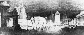
The Louisiana Purchase Exposition or St. Louis World's Fair was the greatest event in the City's history. It has never been exceeded in size or grandeur by any other fair, before or since.
The fair covered 1, 272 acres in the vicinity of the western half of Forest Park and was carried to a successful culmination under the leadership of David R. Francis. The fair celebrated the centennial of the Louisiana Purchase and transformed Forest Park into a veritable fairyland of white palaces, lagoons, and landscaping, attracting 20,000,000 visitors to the City. The fair focused worldwide attention on St. Louis and caused increased construction of new hotels, office buildings, and homes, which continued until World War I.Throughout this time, St. Louis industry enjoyed a steady substantial growth. The City became the world's largest producer of beer, shoes, stoves, wagons, and many other products. Because of diversified industries, St. Louis managed to weather depressions and financial panics more successfully than many other cities.
The St. Louis Transit Company, created by transit consolidation in 1899, was succeeded by the United Railways Company. In 1907, this company absorbed the last remaining independent line, the St. Louis and Suburban Railway Company. This became the Hodiamont division of the local transit system. It is interesting to note that this line began as a narrow gauge steam railway line in 1869, running from Grand and Olive to Florissant through Wellston and Ferguson.
Between 1900 and 1917, there was an in-filling of residential areas between major arteries, streets not so defined because of their width, but rather because they were connecting links between small outlying communities. A by-product of this trend was the establishment of local shopping centers along these streets and at their intersections. The public transit system also tended to follow these thoroughfares, thus strengthening their importance. In 1908 the City constructed the first free highway bridge across the Mississippi River and in 1909, St. Louis celebrated the centennial of its incorporation as a town. The City's population in 1910 climbed to 687,029, retaining the position of St. Louis as the fourth largest city in the United States.
During the early Twentieth Century, many changes transpired in the central business district. New office structures were built such as the Railway Exchange, completed in 1914 as the City's largest.Larger hotels were replacing the fine hostelries of the Nineties. Opening in 1904 at the western edge of downtown, the Jefferson Hotel became the largest. It was followed by the Statler in 1917, the Mayfair in 1925 and the Lennox in 1929. As the center of activity moved westwardly away from the Old Courthouse, old prominent hotels in that area were closed. The Southern's long career ended in 1912 and the Planter's was converted to an office building in 1922.
The old theatrical district of the 1890's, which centered around Broadway and Walnut, gradually turned into a warehouse district. The famous Olympic Theater closed in 1916. Newer theaters which were built in the new central area included the Orpheum at Ninth and St. Charles Streets in 1916, Loew's State in 1923 and the Ambassador in 1926.
Business activity and construction went into a temporary eclipse during World War I, but 1918 witnessed a resumption of building throughout the City. The founding of the Zoo in 1913 and of the Municipal Opera in 1919 were prominent civic events of this era. In 1920 St. Louis, with 772,897 inhabitants, slipped to sixth place in population. The City was still growing, but not so rapidly as others which had annexed additional area.
The first effort to coordinate the City's street pattern came in 1917, when the recently organized City Plan Commission published its first major street plan. The majority of the street widenings, connections and openings which were accomplished under the 1923 bond issue were based upon this plan. The City is indebted to the wisdom of the electorate of 1923 for wide streets such as Olive, Market, Gravois, and Natural Bridge. A glance at a city map made prior to these improvements shows many of these streets to be in 60 feet rights-of-way accommodating only two streetcar tracks and one lane of parking on each side. In addition, they were paved with cobblestones, a rough surface for motorists. The passage of the 1923 bond issue of $87, 000, 000 was a notable achievement in a period characterized by a much slower growth rate than had been enjoyed immediately after the World's Fair. St. Louis became aware of its outmoded physical features and gave itself an extensive face lifting by means of the bond issue. Civic inertia was attacked on many fronts resulting in new hospitals, electric street lighting for the entire City, construction of the Memorial Plaza, Kiel Auditorium and the Civil Courts building, as well as extensive street improvements. The largest single project to be completed was the River Des Peres drainage works which eliminated an open sewer in the West End and provided for proper drainage of flood waters over the full length of the stream within the City.
A revolutionary change in the City's transit system began during the 1920's. The peak period for trolley car operation in St. Louis was from 1910 to 1920 when over 300 miles of track were in use. This rail system extended to practically every developed portion of the City. Increased use of private automobiles and the increased costs of track maintenance as well as new bus lines all contributed to its decline.
Bus operations began with the Missouri Motorbus Company in 1921. This company operated only one line and soon financial difficulties caused its abandonment. A more ambitious system was organized in 1923 by the Peoples Motorbus Company, which soon became a serious competitor of the United Railways Company. This bus company operated both single and double deck busses and adhered to a policy of a seat for every passenger.
The street railway company also operated bus lines as feeders for the trolley lines. The United Railways Company, after a long period of receivership, was reorganized in 1927 as the St. Louis Public Service Company. This firm absorbed the Peoples Motorbus Company in 1930.
The full development of Forest Park was realized through restoration work in its western part following the World's Fair. The fair site had been left as a wilderness until the exposition construction began. One of the primary conditions of the City ordinance which authorized the park's use for the fair required the redevelopment of the site into a park-like area. This part of the park now contains its main attractions. The Zoo was established with the World's Fair bird cage as its nucleus. The Art Palace was given to the City by the Exposition Company for use as a permanent art museum. The Jefferson Memorial building was constructed partially with fair funds as a remembrance of the Louisiana Purchase, and the World's Fair pavilion was built as part of the park landscaping restoration program.
The last large park acquired by the City was Fairground Park, purchased in 1910 from the defunct Agricultural and Mechanical Fair Association, which had operated the old St. Louis Fair on the site until 1903. Francis Park was donated to the City in 1917.
St. Louis enjoyed a period of extensive building construction during the prosperous 1920's. Much of this activity was represented by new apartment and hotel buildings, particularly along Lindell Boulevard and in the West End. Lindell emerged as the City's show street with the erection of such large hotels as the Chase, Park Plaza, Coronado, and Melbourne, as well as such monumental structures as the Masonic Temple and the Scottish Rite Cathedral. The Grand and Olive district became the theatrical center when the large Fox, Missouri and St. Louis theaters were erected during the twenties. Toward the end of this decade the Continental building was completed, a skyscraper on Olive west of Grand.
Subdivision activity took place with renewed vigor during the twenties, absorbing many of the remaining large vacant areas in the extreme southern, southwestern, and northwestern parts of the City. The largest of these subdivisions, St. Louis Hills, was developed by the Willmore organization between 1928 and 1940. It included the entire area south of Chippewa Street and west of Hampton Avenue. This development was aided by the extensions of Hampton south to Gravois and of Chippewa west into the county.
In 1926 the voters defeated a plan to expand the city limits so as to include all of St. Louis County and in 1930 a proposal for a plan of federation under a state constitutional amendment was defeated by the electorate.
The transatlantic flight of Charles A. Lindbergh in the "Spirit of St. Louis" in 1927 was an important civic event in St. Louis. It gave impetus to the development of aviation facilities which led to the creation of Lambert Municipal Airport and its present impressive terminal building.
In September, 1926 St. Louis experienced its second destructive tornado. It was centered in the City's western and midtown sectors.
St. Louis was passed by Los Angeles in the 1930 census, thereby dropping to seventh place in population, with a figure of 821,960.
The depression of the 1930's affected St. Louis in much the same manner as other cities. There was a general deterioration of economic conditions, large scale unemployment and a halt to most building construction. Fortunately for the City, there were many projects from the 1923 bond issue which were still incomplete. These were later supplemented by another bond issue in 1934. The construction of Memorial Plaza during the early thirties furthered the westward trend of the central business district, although the principal stores remained east of Twelfth Street.
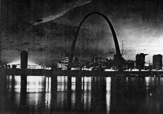
In an effort to stabilize land values in the downtown area, it was felt that a major civic attraction was needed along the riverfront. This led to the promotion of the Jefferson National Expansion Memorial in 1935. In that year, St. Louisans voted for a bond issue to cover the City's share of the project cost, a joint venture with the U.S. National Park Service. Demolition for the proposal was completed in 1940, but progress on the project was delayed by railroad track relocation problems along the riverfront, and by World War II and the Korean War. A memorial design by Eero Saarinen was chosen in an architectural competition in 1948. Federal funds were finally approved and work began in the early 1960's .
St. Louis' population dropped slightly in 1940 to 816,048, a decrease of about 5,000 from the 1930 peak figure. The City's rank in population was eighth among the American cities.
During the late thirties, St. Louis began to display indications of overcoming the civic inertia which had characterized it in recent years. The dramatic decrease of smoke pollution in 1940 was a remarkable achievement and was a forerunner of a new civic spirit after World War II.
Once again, wartime impetus gave a boost to local industry and resulted in construction of many wartime plants, ending the unemployment of the depression. The benefits of the wartime activity can be illustrated by the McDonnell Aircraft Corporation (now McDonnell Douglas) which has grown to be the area's largest employer.
The population of the City of St. Louis attained a new high in 1950, reaching a total of 856,796. This increase allowed the City to retain its eighth place in population rank.
A bond issue was passed in 1944 to provide for a post-war public works program similar to the W. P. A . which had benefited the City during the thirties. The majority of its projects were ultimately consummated, although delayed in anticipation of a post-war depression which did not materialize. In 1953 a bond issue was approved which made possible the Plaza Square apartment project west of Memorial Plaza. The year of 1955 marked approval of a $110,000,000 bond issue. It proved to be as important to the City as was the bond issue of 1923.
These bond issues resulted in the development of Chain of Rocks, River Des Peres, and Willmore Parks. In addition, many other needed civic improvements were accomplished.
A major change occurred in the local transit system when the St. Louis Public Service Company was purchased by the National City Lines of Chicago in 1939 resulting in the introduction of more modern streetcars and diesel busses after 1940. Several transit innovations such as express and loop bus lines as well as the ParkRide operations have been added. The most important recent development in local transit operations was the absorption of the Public Service Company and all other local metropolitan bus lines by the Bi-State Development Agency in 1963. Soon thereafter, the last remaining streetcar lines were abandoned in 1966.
In the field of inter-city transportation, the period since the end of World War II has seen the decline of rail passenger traffic and a consequent upsurge in the rise of air and bus lines. Locally, this has resulted in greatly diminished use of Union Station and expansion of the airport and bus terminals.
Railroad freight traffic has continued to increase and the City has strengthened its position as the nation's number two rail and trucking center. Bulk shipments by barge on the inland river system at the port of St. Louis have more than doubled since 1950.
The first element of a major traffic distribution system was completed in 1936 with the opening of the Oakland Expressway Highway. Automobile traffic increased to such an extent after World War II that by the middle 1950's, the City's street system was unable to accommodate its volume. The surface street system is being supplemented by the construction of a network of expressways spreading in several directions from the City's business center. They are being built as part of the Federal government's interstate highway system, which will ultimately provide a limited access highway network throughout the nation. In St. Louis the first of these to be completed was the Mark Twain Expressway (I.R. 70) connecting downtown, the airport and the Northwest County. Others connect downtown with southern and western St. Louis County as well as communities across the river in Illinois via the new interstate bridge, completed late in 1967.
The redevelopment of the eastern portion of the Central Business District, which began with the Jefferson National Expansion Memorial, was accelerated in 1962 by approval of a bond issue authorizing the City's share of the Civic Center Redevelopment project. The principal feature of this project is the 50,000 seat Busch Memorial Stadium. The completion of the Gateway Arch and the Stadium has not only given St. Louis tourist attractions of national stature, but has initiated a riverfront renaissance by stimulating projects such as Mansion House apartment center, Gateway Tower, the Pet Incorporated building, Stouffer Riverfront Inn, Spanish International Pavilion, Equitable Life building, and the Laclede's Landing project. Completion of the riverfront national park awaits appropriation of Federal funds. An extension of the landscaped Gateway Mall has been proposed westward from the Old Courthouse to the Civil Courts building.
During the 1950's the Metropolitan Sewer District was created as an agency controlling sewers for the City and a major part of the County. It is now engaged in a $95,000,000 construction program of treatment plants and interceptor lines to banish sewage pollution in the Mississippi River. Nearing completion is a City-Federal project to construct levees and floodwalls along the riverfront, ending the danger of flooding in St. Louis from the Mississippi.
Various proposals for coordination of government between the City and County were considered by a board of freeholders created for that purpose in the late 1950's. They approved a district plan scheme; however, it was defeated in an election in 1959. Three years later, in 1962, the freeholders submitted a plan for a borough system of government in the City and County. This was a state constitutional amendment and was also defeated by the voters. Two major steps toward metropolitan cooperation have recently occurred. One is the creation of the City-County Junior College District in 1962, and the other is the formation of the East-West Gateway Coordinating Council in December, 1965 for the purpose of guiding and coordinating programs having metropolitan significance .
St. Louis has totally developed almost all areas within the present city limits. A major urban problem of today in St. Louis, as well as in most major American cities, is the trend of blight which is encompassing a great portion of the city. This blight is being attacked in several ways in St. Louis. In the area west of downtown, the vast Mill Creek Urban Renewal project has cleared an extensive slum area and replaced it with a huge complex of housing, industrial parks, commercial facilities and the eastward expansion of the campus of St. Louis University. A similar project, more industrial in character, has been developed in the near south side Kosciusko area. The West End Urban Renewal area is currently being developed and includes rehabilitation as well as new construction. Other renewal areas are either underway or in survey and planning stages including DeSoto-Carr, Mill Creek North and LaSalle Park .
St. Louis also shares with other cities the problem of an increasing non-white ghetto population. In recent years the profile of the City's population has been radically altered by the influx of large numbers from rural areas. This has been accompanied by the outmovement of many white middle-income residents to the suburbs. The combined migrations have caused a shrinking of the City's taxable base and consequent difficulties in urban finances, as well as the need for increased social programs.
Another urban problem shared with other American cities is that of air pollution. Efforts are now being made toward metropolitan bi-state cooperation to overcome this problem. The elimination of this condition is of importance to a continued amenable urban life.
St. Louis ranked tenth among American cities in the 1960 census with a population of 750, 026; this was the lowest such figure since before 1920. The declining trend seems to be continuing, as the latest estimates indicate that the City's population is less than 700,000. As noted, this trend is partially explained by the continued exodus of residents to the suburbs coupled with fixed corporate limits. Another factor has been the removal of many dwelling units for expressways and urban renewal projects. However, the decrease in the City's population is not reflected in the overall metropolitan area, for it continues to demonstrate a healthy population growth.
This document illustrates the multi-stage development of St. Louis from its initial establishment through periods of growth, change and decline to the recent resurgence of activity. The City's role in the future growth of the region must be continually reassessed in light of both past and current perspectives in order to insure maximum utilization of its potential. To assist in gaining this insight, it is hoped this report will be of some contribution.
Billon, Frederick L.		Annals of St. Louis - The French and Spanish Period.
				Nixon-Jones Printing Co.,  St. Louis, 1886

Billon, Frederick L.		Annals of St. Louis in Its Territorial Days.
				Nixon-Jones Printing Co., St. Louis, 1888.

Civic League of St. Louis	A City Plan for St. Louis.
				St. Louis, 1907.

Cox, James			Old and New St. Louis. Continental Printing Co.,
				St. Louis, 1894.

Darby, John F.		Personal Recollections. G. I. Jones Printing Co.,
				St. Louis, 1880.

Devoy, J. A.			History of St. Louis and Vicinity,
				St. Louis, 1898

Edwards, Richard and		The Great West and Her Commercial Metropolis.
Hopewell, M.			St. Louis, 1860.

Flint, Timothy			Recollections of the Last Ten Years.
				Boston, 1826.

Gill, McCune			Titles to St. Louis Real Estate.
				St. Louis, 1920

Hogan, John			Thoughts About the City of St. Louis.
				St. Louis, 1854.

Hyde, William and		Encyclopedia of the History of St. Louis - 4 Vols.
Conard, Howard		New York, 1899

Lange, Dena			History of St. Louis - 2 Vols. Public School Messenger,
				St. Louis, 19930-1931.

Lass, William E.		Tourist's Impressions of St. Louis - 1766 -
				1859. Missouri Historical Review,
				Columbia, Mo., July-October, 1958

Reavis, L. U.			St. Louis, The Future Great City of the World.
				Gray and Beyer Co., 1875.

Scharf, J. T.			History of St. Louis City and County, Louis H. Everts Co.
				Philadelphia, 1883.

Shepard, Elihu H.		The Early History of St. Louis and Missouri.
				St. Louis, 1870.

Stevens, Walter B.		St. Louis, The Fourth City. S.J. Clarke
				Publishing Co., St. Louis, 1909.

Wandell, Harry B.		The Story of a Great City in a Nutshell,
				St. Louis, 1900.
1764		ST. LOUIS FOUNDED. Construction of houses begun.
1766		"Livre Terrien" book opened to record land titles.
1770		Village of Carondelet founded.
1776		First church building completed.
1779		Rowboat Ferry started across river.
1780		Third Street added to town plat.
1798		CITY POPULATION: 925
1804		TRANSFER OF LOUISIANA TERRITORY FROM FRANCE TO U.S.A.
1808		First newspaper printed.
1809		TOWN OF ST. LOUIS INCORPORATED.
1813		First brick house built.
1816 		U.S. land office opened. First additions to town.
1817		First steamboat arrived.
1818		First streets paved.
1821		First sidewalk laid. First City Directory published.
1822		ST. LOUIS INCORPORATED AS A CITY.
1827		U.S. arsenal established.
1829		St. Louis University opened. Brick courthouse completed.
1832		Water began to be distributed by waterworks.
1833		Public schools incorporated.
1835		Paving of wharf begun.
1837		Gaslight Company incorporated.
1839		New City Charter. Change in City Limits.
1840 		CITY POPULATION: 16,469; assessed value: $8,682,000.
1841		CITY LIMITS EXPANDED TO AREA OF 4.50 SQUARE MILES.
1844		Lafayette Park purchased. Record flood water.
1847		City Hospital opened. Telegraph lines reached City.
1849		FIRE DESTROYS 15 CITY BLOCKS AND 23 STEAMBOATS.  CHOLERA EPIDEMIC.
1850		CITY POPULATION: 77,860; assessed value: $29,676,000. First sewer built.
1853		First public high school opened. Forerunner of Washington
		University incorporated.
1855		CITY LIMITS EXPANDED TO AREA OF 13.94 SQUARE MILES
		Pacific Railroad opened. St. Louis Agricultural Fair founded.
1857		City fire department inaugurated.
1859		Street railway operations commenced.
1860		CITY POPULATION: 160,733.
1861		Battle of Camp Jackson. Metropolitan Police System established.
1862		Courthouse completed.
1865		Public school library opened.
1869		Tower Grove Park donated by Henry Shawl
1870		CARONDELET ANNEXED. CITY AREA: 17.98 SQUARE MILES.
		CITY POPULATION: 310,869.
1873		First public school kindergarten opened.
1874		DEDICATION OF EADS BRIDGE. (National Monument)
1875		Forest, O'Fallon and Carondelet Parks purchased.
1876 		CITY SEPARATED FROM ST. LOUIS COUNTY. CITY
		LIMITS EXPANDED TO AREA OF 61.37 SQUARE MILES.
1878		Public telephone service inaugurated.
1880		CITY POPULATION: 350,318. 600  telephones in use.
1884		Use of streets for sale of electricity authorized.
1887		Electric trolley car lines began operation.
1889		Terminal Railroad Association organized.
1890		 CITY POPULATION:  451,770.   2,885  telephone subscribers.
1891		Boulevard system authorized.
1894		Union Station opened.
1896		Devastating tornado swept over City on May 27th.
1898		First automobiles appeared on City streets.
1899		Consolidation of transit lines accomplished.
1900		CITY POPULATION:  575,238. 6,237 telephones in use.
1903		Union Electric Company, consolidated power companies.
1904		WORLD'S FAIR TO CELEBRATE LOUISIANA PURCHASE
		HELD IN FOREST PARK AND VICINITY. Clear water achieved by water works.
1908		Municipal free bridge constructed.
1909		Celebration of centennial of town's incorporation.
1910		CITY POPULATION: 687,029
1911		City Plan Commission created.
1912		St. Louis Zoo founded.
1914		NEW CITY CHARTER ADOPTED.
1919 		Municipal Opera began performances.
1920 		CITY POPULATION: 772,897.
1923 		$87,000,000 CIVIC IMPROVEMENT BOND ISSUE APPROVED.
1930		CITY POPULATION: 821,960.
1935		BOND ISSUE FOR JEFFERSON NATIONAL EXPANSION MEMORIAL APPROVED.
1936		Oakland Express Highway opened.
1939		Smoke elimination law passed.
1940		CITY POPULATION:     816,048.
1942		Public Housing program started in St. Louis.
1943		Small Arms Plant opened.
1944		Post-War Bond Issue passed.
1950		CITY POPULATION: 856,796.
1953		Plaza Square Bond Issue approved.
1954		Metropolitan Sewer District created.
1955		Approval of $110,000,000 Civic Improvement Bond Issue.
1959		District Plan of Government defeated. Tornado on February 10th.
1960		CITY POPULATION: 750,026.
1961		Mark Twain Expressway opened.
1962		City's share of stadium project cost approved in bond issue election.
		Borough plan defeated.
1963		All area transit operations assumed by the Bi-State Development Agency.
1964		BI-CENTENNIAL OF CITY'S FOUNDING CELEBRATED.
1965		East-West Gateway Coordinating Council established.
1966		Busch Memorial Stadium dedicated. Last streetcar line abandoned.
1967		Gateway Arch opened to public use. Poplar Street Bridge opened.
1968		GATEWAY ARCH OFFICIALLY DEDICATED - MAY 25th.
Although numerous staff members have contributed to the production of this document, particular recognition is expressed to Mr. Norbury Wayman for his work in research and developing the text.
CITIZEN MEMBERSJ. Kenneth Hyatt, ChairmanCharles L. Farris, Vice-Chairman Miss Olivia E. Banks Ernest Calloway Robert A. Griesedieck James M. O'Flynn Daniel P. Reardon, Jr. William D. Rund Alvin A. Wolff |
MEMBERS EX- OFFICIODonald Gunn, President, Board of AldermenJoseph W. Martino, Member, Board of Aldermen Conway B. Briscoe, President, Board of Public Service Louis W. Buckowitz, Director, Parks, Recreation and Forestry William Trantina, Director of Public Safety C. Larry Unland, Director of Streets Norman Murdoch, Director of Planning and Development Nell Marie Geders, Secretary to the Commission |
ADMINISTRATIVE  DIVISION

Norman Murdoch,
	Director of Planning and Development
Nell Marie Geders,
	Secretary to the City Plan Commission
Gary Crabtree, Planner I
Grace Ummelmann, Typist-Clerk
Nancy Ferrell, Receptionist
Jo Ann Spitale, Typist-Clerk

URBAN DESIGN DIVISION

Ronald J. Nuetzel, Planner IV
Bruce W. Heckman, Planner II
James H. Praprotnik, Planner III

COMPREHENSIVE	PLAN

Dale E. Ruthsatz, Planner III
Donald E. Sims, Planner II
Eugene Cissell, Planner I
David Robinson, Planner I
Walter J. Murphy, Draftsman II

CURRENT  PLANNING

Harry K. Frank, Planner IV
Norbury Wayman, Planner I
Cleo Benda, Draftsman II
Brenda Brown, Draftsman II
James Jones, Engineering Aide II
Barbara Crivello, Clerk I

ST.  LOUIS DEVELOPMENT

Rolland W. McFarland, Planner IV
Philip H. Brown, Planner III
James	D. Schoonover, Planner II
Edward P. Dobbs, Draftsman II
Leonard Hafertepe, Draftsman II
Patricia Walsh, Steno-Clerk